
A comprehensive Review in the Role of Remote Sensing in Climate Change: Applications and Innovations
مراجعة شاملة لدور الاستشعار عن بُعد في التغير المناخي: التطبيقات والابتكارات
Taghreed Shteiwi Falih Al-Daham1
1 Researcher, Jordan.
Email: taghreed_aljboor@yahoo.com
DOI: https://doi.org/10.53796/hnsj71/33
Arabic Scientific Research Identifier: https://arsri.org/10000/71/33
Volume (7) Issue (1). Pages: 511 - 524
Received at: 2025-12-10 | Accepted at: 2025-12-17 | Published at: 2026-01-01
Abstract: This study aims to provide a comprehensive review of the latest developments in remote sensing technologies and their applications in climate change research. Focusing on the integration of advanced satellite sensors, artificial intelligence, and hyperspectral imaging, the review examines how these innovations enhance our ability to monitor and analyze climate phenomena. Key application areas include temperature monitoring, greenhouse gas detection, vegetation dynamics, and sea-level rise assessment. The study highlights the role of remote sensing in early detection of climate anomalies, disaster preparedness, and informed policymaking. By synthesizing existing research, the paper emphasizes the importance of remote sensing not only as a monitoring tool but also as a catalyst for innovation in climate science, supporting global efforts to mitigate and adapt to the impacts of climate change.
Keywords: Remote sensing, Climate Change, Greenhouse gas, Passive Remote Sensing, Active Remote Sensing Systems.
المستخلص: يهدف هذا البحث إلى تقديم مراجعة شاملة لأحدث التطورات في تقنيات الاستشعار عن بُعد وتطبيقاتها في أبحاث تغيّر المناخ. ويركّز على تكامل المستشعرات الفضائية المتقدمة، والذكاء الاصطناعي، والتصوير فائق الطيف، مع استعراض كيفية إسهام هذه الابتكارات في تعزيز قدرتنا على رصد الظواهر المناخية وتحليلها. وتشمل مجالات التطبيق الرئيسة مراقبة درجات الحرارة، والكشف عن غازات الدفيئة، وديناميكيات الغطاء النباتي، وتقييم ارتفاع مستوى سطح البحر. كما تبرز الدراسة دور الاستشعار عن بُعد في الكشف المبكر عن الشذوذات المناخية، والاستعداد للكوارث، ودعم صنع السياسات المبنية على أسس علمية. ومن خلال استخلاص نتائج البحوث السابقة، تؤكد الورقة أهمية الاستشعار عن بُعد ليس فقط كأداة للرصد، بل أيضًا كمحفّز للابتكار في علوم المناخ، بما يدعم الجهود العالمية للتخفيف من آثار تغيّر المناخ والتكيّف معها.
الكلمات المفتاحية: الاستشعار عن بُعد، تغيّر المناخ، غازات الدفيئة، الاستشعار عن بُعد السلبي، أنظمة الاستشعار عن بُعد النشطة.
- Introduction
At recent years, Climate change (phenomenon of weather patterns over several decades) is one of the biggest global challenges. Earth’s climate is impacted by two factors: the first factor is the heating effect from solar energy and the concentration of greenhouse gases (GHG) and cooling effects by volcanic eruptions and aerosol concentrations in the atmosphere (Canadian Institute of Actuaries, 2015). Second factor is human’s activities that cause GHG emissions such as carbon dioxide (CO2) and methane (CH4). In addition, land-use changes cause global temperature increases.
Climate change has a several implications, for example; heat waves, droughts, floods, and storms. These events can lead to heat stress, respiratory problems,, negative impact on human life and waterborne diseases, and other health problems (IPCC, 2013, Ezzati, Lopez, Rodgers, & Murrgay, 2004, Organization for Economic Co-Operation and Development, 2015). the sea levels are changing, displacing people, disrupting food production, and economic impacts … etc.
Despite that the climate science and its recent developments is still new field, and scientists are still studying it and make researches about the relationship between human activities and it. however they found strong evidence that the increase in greenhouse gas emissions (Carbon dioxide (CO2), methane (CH4), nitrous oxide (N2O), perfluorocarbons (PFCs), hydrofluorocarbons (HFCs), and sulfur hexafluoride (SF6)) from human activates over 100 years ago has a great impact on climate, and with continue as global greenhouse gases emissions continue to rise )Watts et al., 2015( ,that make more concerns about these changes, that implicate an increasing for climate monitoring and the reasons for change it on a global scale by data sets useful for it with more accuracy requirements ) Schulz et al., 2009( .
There is great interest to study the impacts of human activities on these changes at the regional and global level in many sectors, such as; transport, electricity production, industry, agriculture, land use, the commercial and residential sectors, and forestry contribute the most to overall greenhouse gas emissions )Sonwani, Saxena, & Kulshrestha, 2016( .also many studies have shown the impact of these activities on the energy balance in climate system by the extraction, burning of fossil fuels and land use, which is an indirect factor of depositing gases in the atmosphere, and transformed the dark, moist surface of the Earth into a bright surface that reflects more incident radiation and is less moist (and thus more reflective) than the original surface ) SpringerLink, 2021, Cox et al., 2000, Lehmann, 2007, Scholz & Hasse, 2008, Sheikh et al., 2011).
To prevent the impacts greenhouse gas emissions on climate and reduce it, many of the most innovative and effective climate solutions are being developed and implemented switching to renewable energy sources, improving energy efficiency, and reducing deforestation) Hoornweg, Sugar, & Gómez, 2011 .(but the challenges are about studying more about the nature of that impact and collecting data about it, so Studying and understanding changes in atmospheric composition is very important for estimating changes in the energy balance of atmosphere. Also, collecting data and measuring the exchange of greenhouse gases and anthropogenic emissions will be useful indicators of global changes, especially studying time dependent emission estimates very effectiveness for emission reduction strategies and improve our understanding of how these processes respond the climate change. So, Scientific developments have clearly contributed for understanding of natural variations that influence climate and other meteorological factors for a long time. In 2022, the official United Nations Climate Change (UNCC) website lists the climate change targets for 43 countries around the world and the Union reports on GHG emissions by sources and removals from sinks for 2020. These reports passed on new technologies.
The interactions between ecological systems and climate dynamics are well-deep, that ecological processes being influenced by climate changes. Monitoring these interactions is essential for predicting and responding to environmental changes, so the good monitoring is essential for sustainable ecological management, particularly in reaction to climate change and increased human use of natural resources )Sarah et al., 2020 ,Danielsen et al., 2022).
Space-based observations deliver the needed global coverage with sufficient quality and timeliness. Satellites have become indispensable tools in climate monitoring, it offering a bird’s-eye view of the Earth’s atmosphere, oceans, and land surfaces. From tracking climate change to observing weather patterns and monitoring environmental phenomena, and it provide sufficiently several data that uses for climate analysis (Santer et al., 2007, Mieruch et al., 2008 and Trenberth et al., 2005). these provide information on the climate system that are not available or difficult to measure from the Earth’s surface like top of atmosphere radiation, cloud properties or humidity in the upper atmosphere the two latter having a large impact on the greenhouse effect.
Satellites provide a wealth of data crucial for understanding the complexities of our planet’s climate system. This article explores the pivotal role that satellites play in climate monitoring and how they contribute to addressing global environmental challenges.
Remote sensing is one of the most effective technological techniques that is used globally to measure and monitor greenhouse gas emissions, measure air quality against standards, identify trends in emission concentrations, provide real-time air quality information, assess community exposure, and validate greenhouse gas models. and emissions inventories )Metrikaitytė, 2023(. Remote sensing allows us to provide a powerful framework for measuring, monitoring and analyzing the impacts of climate change) David et al., 2022, Linda et al., 2013). It is a catalyst towards sustainability and resilience. The use of this advanced technology forms the cornerstone of our understanding of the complex dynamics between climate change and human activities that cause greenhouse gases, which could be relevant in our review.
Remote Sensing: An Overview
Remote sensing (RS) provides an accurate and cost-effective alternative for understanding landscape dynamics, interactions between humans and their environment, and monitoring greenhouse gas emissions )Hartmann, 1994( . These technologies have allowed us to monitor and analyze the impacts of climate change, and understand all those dynamics that cause greenhouse gases, which can be relevant in our review. As a result, rigorous methods of data analysis have emerged, facilitating opportunities to enhance assessments and link weather conditions to land use) Dale et al., 1993( .
Remote sensing is defined according to Janssen (2004) as the process of obtaining information about the characteristics of the Earth’s surface using a sensor (detection device) without the need for direct contact with the objects being measured and the processing of the data use )Deafalla,T. H. H.,Csaplovics,E.,& El‑Abbas,M. M.2014).
In geometrics science, remote sensing is defined as the science of obtaining, processing, and interpreting images with the data used obtained through aircraft and satellite vehicles that record interactions between matter and electromagnetic radiation (Sabins, 2007).
Remote sensing techniques are used in numerous fields, such as: Geography, hydrology, ecology, meteorology, oceanography, glaciology, geology, improving warning and preparedness in disaster risk management, as well as for military scope, intelligence, commercial, economic, planning, and humanitarian applications.in addition, it able to detect and classify objects and characteristics of the Earth system through propagated signals (e.g. electromagnetic radiation). Remote sensing technologies can be satellite-or aircraft-based. (Active) remote sensing techniques refer to a signal directly emitted by a satellite or an aircraft, that is reflected by an object and it is, on turn, detected by the sensor (RADAR and LiDAR), while (passive remote sensing is referred to sensors able to detect radiation that is emitted or reflected by an object or surrounding areas such as: charge-coupled devices, film photography, radiometers, and infrared.
Remote sensing became very important for improving understanding of the climate system and its changes. It enables to monitor the Earth surface, ocean and the atmosphere at several spatio-temporal scales, thus allowing climate system observations, as well as to investigate climate-related processes or long and short term phenomena, as for example deforestation or El Niño trends. Moreover, remote sensing is useful to collect information and data in dangerous (e.g. during fire events) or inaccessible areas (e.g. impervious areas). Since the launch of the Vanguard-2 Satellite in 1959 for observations of solar radiation and clouds, remote sensing has gradually become a leading discipline in the study of climate change; it is one of the most efficient techniques for monitoring land cover changes. Data obtained from remote sensing satellites are also often used in conjunction with climate models for climate system simulations to climate projections. According to) Bayode E, N., 2014).
Key Remote Sensing Technologies for Climate Change Monitoring
Continuing climate change, rising temperatures, rising sea levels, and increasing extreme weather events have made monitoring climate change a global priority. This does not mean that traditional ground-based methods of climate monitoring are not useful, but they are limited by their spatial coverage, cost, and labor intensity Remote sensing technologies have provided effective means of overcoming these obstacles by providing high-resolution, timely, and globally connected data. These techniques have provided monitoring across vast areas and over time, providing insight into different climatic factors (Lillesand et al., 2015).
2.1 Passive Remote Sensing Systems
Passive remote sensing works by detecting natural radiation reflected or emitted from the Earth’s surface. The primary source of radiation for all passive sensors is sunlight, which interacts with the Earth’s surface and atmosphere before bouncing back to the sensor. Passive sensors, onboard Landsat and MODIS satellites, detect reflected solar radiation at different wavelengths (e.g., visible and infrared) to measure land surface properties, vegetation, and temperature (Jensen, 2007).
Applications of Passive Remote Sensing
Climate Monitoring: Passive remote sensing plays an important role in monitoring surface temperatures and atmospheric composition. Satellites such as the Earth Observing System (EOS) and the Moderate Resolution Imaging Spectroradiometer (MODIS) have provided important data for climate change research. These systems are good at monitoring sea surface temperatures, ice cover, and Earth surface temperatures over long-term time periods, as they have contributed to a deeper understanding of climate dynamics. (Jiang et al., 2014).
Land cover and vegetation monitoring: Passive sensors are widely used to derive vegetation indices, such as the Normalized Difference Vegetation Index (NDVI), which has an important role in monitoring deforestation, desertification and land degradation – major drivers of climate change (Tucker, 1979). Tracking forest cover and vegetation health is essential for assessing carbon sequestration and understanding the global carbon cycle (Roy et al., 2014).
Oceanography: Passive sensors have played an important role in oceanography, because they reveal ocean color, plankton productivity, and water quality, providing valuable indicators about ocean health. Additionally, sensors such as MODIS and the Advanced High-Resolution Radiometer (AVHRR) have played a pivotal role in monitoring sea surface temperature (SST), a critical indicator that influences climate patterns such as El Niño and La Niña (O’Reilly et al., 2000).
Active remote sensing works by emitting energy toward a target and detecting the amount of energy reflected or diffused back to the sensor. In this process, we do not rely on natural energy sources, so we are able to collect data day and night. The main active sensing systems include radar, such as synthetic aperture radar (SAR), and LiDAR (Light Detection and Ranging), which emits electromagnetic waves and analyzes reflected signals to extract information about the Earth’s sur face ( Milan et al., 2016 ).
Applications of Active Remote Sensing
Monitoring ice sheets and glaciers: Search and rescue systems are essential for predicting and monitoring ice sheet dynamics, manifested in sea level rise. SAR satellites such as Sentinel-1 have helped Tracking and monitoring surface deformation and ice flow in the polar regions, which contributed to providing a necessary database to evaluate the impact of melting glaciers on global sea levels (Rignot et al., 2016).
Disaster management: SAR data is important in monitoring flood events, landslides, and earthquake damage. Its ability to penetrate cloud cover and operate in all weather conditions makes SAR an effective tool for monitoring disasters in real time (Prats et al., 2016).
Topography and forest biomass: LiDAR systems have provided a highly accurate database of the Earth’s surface, enabling precise measurements of forest canopy height and biomass, which are fundamental to understanding carbon storage (Simard et al., 2011). The LiDAR system has had an important role in mapping coastal areas and monitoring the effects of sea level rise on coastal erosion (Gao et al., 2012).
- Significance of the Study
This review aims to evaluate the applications of remote sensing technology in climate studies and future predictions in climate science. It reviews research articles published between 2000 and 2024 on the use of remote sensing technology and its applications in climate research. Through this literature review, we examine the advantages, limitations, uses, challenges, and scope of remote sensing in climate monitoring. We also explore how remote sensing contributes to a better understanding of climate dynamics and its practical applications.
3. Objectives of The Study
In this review, we selected scientific articles that address the role of remote sensing in climate change and conducted a content analysis. Google Scholar and open-access journals are essential databases for literature searches. Previous studies have shown that remote sensing provides a more in-depth view of how Earth’s climate is changing. Using satellite technology, scientists can more accurately predict future climate and determine the impact of mitigation and adaptation measures.
and evaluate the Remote Sensing (RS) application which have been used to obtain data about the characteristics of the Earth’s surface using a sensor (detection device) without the need for direct contact with the objects being measured and the processing of the data
. In addition, understand landscape dynamics and the interactions between humans and their environment (Dale et al., 1994). Which are accurate methods for data analysis, facilitating opportunities to enhance assessments and connect atmospheric conditions with land use )Deafalla, T. H. H., Csaplovics, E., & El‑Abbas, M. M. 2014).
However, few studies have focused on the challenges and solutions associated with them, such as the impact of spatial and temporal resolution and sensor limitations. Several findings from previous studies have been adopted to evaluate the effectiveness of remote sensing in climate monitoring: (a) the main content related to the role of sensing in climate monitoring (advantages), (b) the focus on the effectiveness of remote sensing applications in climate monitoring, and (c) the focus on the challenges of using remote sensing in climate monitoring, based on the previous studies we reviewed.
Based on the results of research papers retrieved from 2000 to 2024, researchers have strived to apply remote sensing in climate monitoring studies and research and to adopt it as an important source in climate research.
4. Applications of Remote Sensing in Climate Change Research
1-Monitor temperatures and Atmospheric Changes
Satellite remote sensing has played an important role in tracking changes in temperatures, greenhouse gas concentrations, and cloud cover, providing a basic database for climate change research, such as tools such as the Atmospheric Infrared Sounder (AIRS) and the Moderate Resolution Imaging Spectroradiometer (MODIS) that have enabled continuous tracking of atmospheric interactions (Masiello & Serio, 2013). Land surface temperature (LST) is an important indicator of climate change and its impact on micro-ecosystems. Remote Sensing such as NASA’s MODIS and Landsat sensor series are sources of global temperatures that they use for climate work and forecasting. These satellites played an important role in making important insights into temperature fluctuations in the short and long term and the paths of global warming by detecting extremes in temperature, and remote sensing helped identify areas at risk and develop supportive strategies for mitigation and adaptation. (Cheng et al., 2017). Table 1 below shows summary data on major satellite instruments and their uses for tracking atmospheric and temperature-related parameters.
- Table 1: Key Satellite Instruments for Monitoring Temperature and Atmospheric Changes.
|
Instrument / Sensor |
Agency |
Main Function |
Temporal Coverage |
Spatial Resolution |
Application Focus |
|
MODIS (Terra/Aqua) |
NASA |
Monitors LST, cloud cover, aerosols |
Daily |
250–1000 |
Climate modeling, vegetation, water stress |
|
AIRS |
NASA |
Tracks atmospheric temperature and humidity |
Twice daily |
~13.5 km |
Greenhouse gases, atmospheric profiling |
|
Landsat (8 & 9) |
NASA/USGS |
High-resolution LST data |
Every 16 days |
30–100 m |
Urban heat islands, ecosystem monitoring |
|
Sentinel-3 (SLSTR) |
ESA (Europe) |
Monitors SST and LST |
Daily |
500 m – 1 km |
Ocean temp, land climate |
|
VIIRS (Suomi NPP) |
NASS/NOAA |
Monitors surface temp and cloud properties |
Daily |
375–750 m |
Monitors surface temp and cloud properties |
Resource: (NASA EOSDIS, 2020)
2-Studying the dynamics of snow extension and ice cover
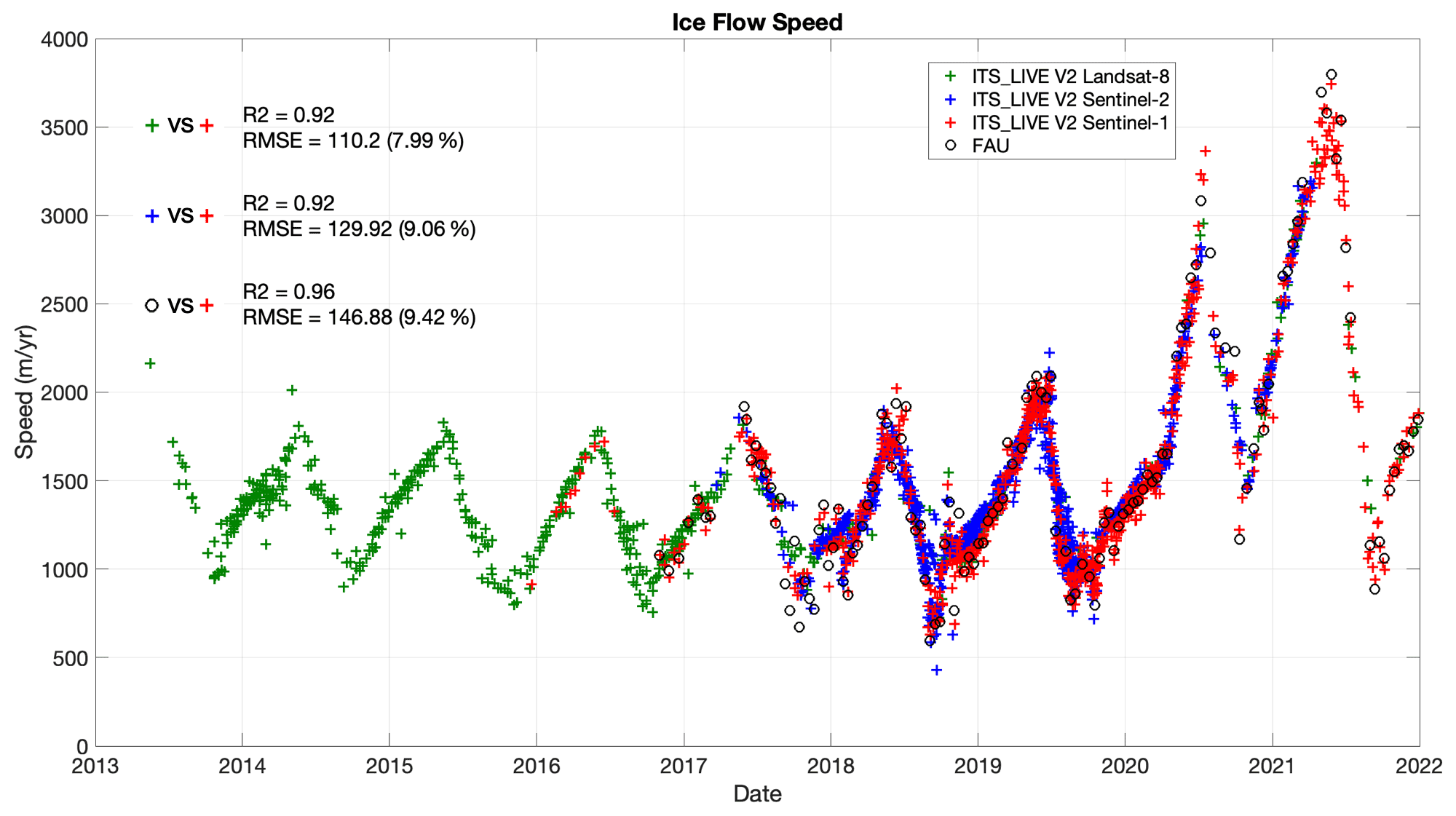 Remote sensing satellites can track snow cover extent, duration, and depth, providing data on climate change-related shifts in snow patterns and their impacts on water resources and ecosystems which provide more understanding the Earth’s energy balance. Sentinel-1 and ICESat-2 satellites provide valuable data for assessing ice loss and its contribution to sea-level rise (Velicogna et al., 2020).
Figure 2- 1 shows the time series of ice flow speed as inferred from ITS_LIVE data using radar images from Sentinel-1, compared to speed results from Sentinel-2 and Landsat-8.) Lei, Y., Gardner, A. S., & Agram, P. 2022).
–3Monitoring sea-level changes and coastal modifications
Satellites equipped with sensors such as LiDAR and radiometers, like NASA’s GRACE,These techniques provide data to assess the impacts of rising sea levels on coastal communities (Gao et al., 2012). provide accurate data on changes in sea level and the factors contributing to sea level rise. In addition, a study conducted by Kavak and Karadogan (2011) played the role of applying remote sensing to monitor the effects of changes in global temperature on marine life by observing the relationship between phytoplankton chlorophyll and sea surface temperature in the Black Sea.
-4 Monitoring vegetation status and change
Vegetation is increasingly threatened due to anthropogenic and climatic influences. So, the world’s forests are increasingly limited, vulnerable. The challenge for ecologists and biogeographers understands the place-time patterns of vegetation. Remote sensing technologies like multispectral and hyperspectral imaging enable scientists to analyze vegetation health, productivity, and phenology. Analyzing vegetation changes helps researchers identify regions affected by climate change-related impacts such as drought, forest degradation, or shifts in growing seasons) Walia, Hao, & Qu, 2023, Zhang et al., 2021, Eamus, Huete, & Yu, 2016) Remote sensing platforms such as Landsat and Sentinel-2 have provided detailed land cover maps to monitor deforestation rates and vegetation changes over time (Achard et al., 2014).
-5 Soil Moisture Monitoring:
Remote sensing satellites with microwave radiometers and synthetic aperture radar (SAR) systems can measure soil moisture, providing insights into the impacts of climate change on water availability, drought risk, and land degradation. In addition, Soil is the largest reservoir on the earth’s surface that can store 3.3 times more carbon than the atmosphere. Erosion of water can cause decomposition of the soil resulting in the release of carbon. Through remote sensing integrated with the discipline of hydrology, it can be used to predict the impact of land cover changes on surface runoff and sediment in an area( Grünwald et al., 2020,Famiglietti et al., 2019).
6- Monitoring water resources and impact due to droughts and dry periods:
Climate change is predicted to increase the risk of flooding worldwide. So that remote sensing is used as the primary tool for mapping flood-prone zones. it help monitor and predict floods by measuring precipitation, soil moisture, and vegetation health. It was able to identify areas vulnerable to floods through
thematic maps, including road networks, water sources, land use, population density which are then managed for decision making. then enabling disaster management agencies to take preventive measures and respond effectively to climate change. In other side, Drought is when the annual rainfall is less than average, when the monthly or seasonal rainfall is less than average, and when river flow and groundwater availability decrease. As well as desertification decreases soil’s biological or economic productivity in dry and semi-arid areas due to land degradation. Remote sensing satellites can provide continuous observations for drought monitoring, desertification, and assessing damage to food crops )Al-Juaidi et al., 2023).
7- Monitoring fire events and fire emissions:
Remote sensing satellites, like those with MODIS or VIIRS sensors, can detect and monitor forest fires, providing real-time data on fire location, size, and intensity. This information helps researchers understand the role of climate change in increasing the frequency and severity of wildfires, as well as informing firefighting and forest management efforts) Giglio et al., 2016.(
8- Precipitation Monitoring:
Satellites equipped with microwave radiometers or passive microwave imagers measure precipitation rates and distribution, providing data on global and regional trends. Analyzing precipitation changes is vital for understanding climate change impacts on water resources, agriculture, and disaster risk reduction (Kidd et al., 2021).
9- Biodiversity Conservation:
Biodiversity is currently disrupted mainly due to the impact of climate uncertainty. Various animal species are threatened with extinction due to habitat degradation. Remote sensing can be applied for conservation needs, such as estimating the number of an animal species based on the characteristics of its habitat (Skidmore et al., 2006(.
10-Health and Disease Outbreaks:
Scientific evidence has shown that climate change has severe health impacts. Climate
change events such as floods, storms, and heat waves cause short- and medium-term
diseases, while drought and desertification can limit the access of the poor to clean water. Changes in temperature and extreme weather can also cause respiratory problems, fungal growth, skin cancer, and cataracts to insect-borne diseases. Remote sensing can be
utilized for disease mapping. Statistical associations are shown between ecological variables and processes that can be observed remotely, such as rainfall, temperature, land cover, and humidity.
There are other uses for remote sensing relevant for climate change adapting to emerge (Yang, J., et al., 2013; Mutanga, O.; et al., 2017; Wan, Z.; et al., 2004), such as:
- Natural resource management and forest and water management.
- Management of agricultural practices, for example related to land use, land conservation and soil carbon stock.
- Tactical forest fire-fighting operations in real-time decision support systems.
- Monitoring of land cover and its changes over different temporal and spatial scales, even after a disaster event.
- Simulation of climate system dynamic and Improvement of climate projections and meteorological reanalysis tools widely used for climate change research studies.
- Developing early warning and forecasting systems to reduce and manage climate-related disaster risk, as well as helping to be prepared for actions.
- Postdisaster damage detection based on comparative analysis of before and post disaster images. Its data also useful for emergency workers.
5. Innovations in Remote Sensing Technologies
Remote sensing technology has become an effective means of studying climate change and mitigating its effects, as it has provided innovative ways to monitor and analyze the Earth’s dynamic systems. Recent developments and future trends in remote sensing applications have played an enhanced role in climate research.
1 -Small Satellites and CubeSats
The dramatic development in small satellites, or CubeSats, has led to a reduction in the cost of space monitoring. This is because the satellites are cheap and are able to provide high-resolution
Data for climate change studies, making it possible for many research institutes and developing nations to monitor climate using satellites. (Culbertson et al., 2017).Table 1 below outlines the primary differences bet
ween CubeSats and traditional satellites in terms of cost, size, and focus on application.
Table 2: Comparison Between CubeSats and Traditional Satellites
|
Feature |
CubeSats |
Traditional Satellites |
|
Development Cost |
$50,000 – $500,000 |
$100 million – $500 million |
|
Development Time |
6 months – 2 years |
5 – 15 years |
|
Size & Weight |
1–10 kg |
500+ kg |
|
Launch Cost |
Low (can be rideshare payloads) |
High (requires dedicated launch) |
Recourse: (NASA, 2020)
-2High-resolution satellite images
The tremendous progress in modern satellite technology, such as those in the Sentinel-3 series, has provided high-precision and quality data in monitoring the terrestrial and marine environments, as it has the ability to measure the topography of the land and sea surface, the temperature of the land and sea surface, and the color of the surface, which has provided a huge and comprehensive database for climate analysis (European Space Agency, 2020).
-3Hyperspectral Imaging
Collecting detailed spectral data across a broad range of wavelengths is made possible through hyperspectral imaging, a new advancement in remote sensing. With this technology, it is now possible to detect changes in land cover, vegetation, and atmosphere, which are important indicators of climate change. Satellites, such as NASA’s AVIRIS (Airborne Visible/Infrared Imaging Spectrometer), with hyperspectral sensors are transforming the monitoring of climate-sensitive activities with more precise detail (Zhang et al., 2020).
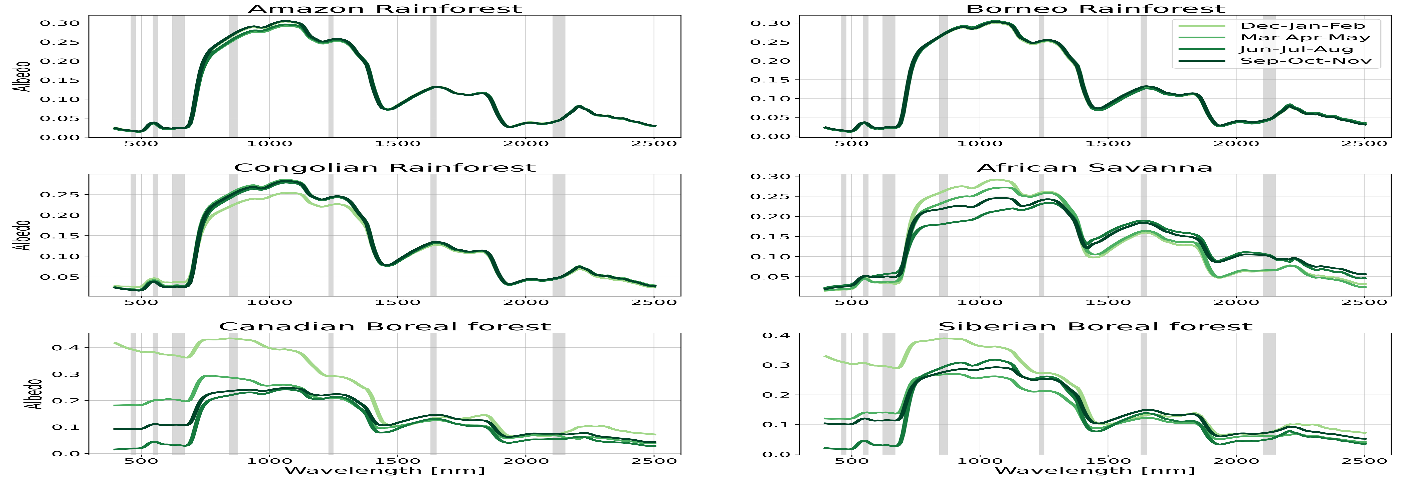
Figure shows the surface spectral reflectance (albedo spectra) of different forest regions around the world (Amazon, Borneo, Stepana, African Savanna, and northern forests such as Canada and Siberia) during the four seasons, with an average spectral reflectance ranging from nanometers. (Roccetti et al., 2024)
4-Global Satellite Networks and Cooperation
A better global collaboration of the space agencies, industry, and international partners in the coming days will drive the future remote sensing using satellites. Global satellite constellations such as Copernicus are increasing, with larger usage of smaller satellites providing constant observation of data about our world, intensifying our capabilities of monitoring earth environment changes at the moment in time European Space Agency (European Space Agency, 2023 (.
5-Artifical Intelligence and Machine Learning for Data Processing
With the fast-growing satellite data, artificial intelligence and machine learning play an increasing role in processing and managing remote sensing data. These technologies have the capability to advance the efficiency and accuracy of climate change observations through data classification automated processing, change detection, and forecasting modeling (Zhang et al., 2020).
7. Challenges and Limitations in Remote Sensing for Climate Change
Remote sensing is significantly important in climate change research, yet it is constrained by various challenges that limit its optimal potential. One of the key limitations is the:
(i) Spatial and temporal resolution capability of existing satellite sensors. High-resolution data is essential in the detection of detailed fluctuations in climate phenomena, yet satellite sensors tend to be unable to deliver required resolution, which can impact environmental monitoring precision. For example, satellites with higher spatial resolution monitor smaller areas, and it is difficult to observe large-scale environmental change at an effective rate (Scholz & Hasse, 2008).
(ii) Temporal resolution constraints mean that remote sensing sensors will not return to the same location frequently enough to observe rapid changes, such as extreme weather conditions. For instance, the Moderate Resolution Imaging Spectroradiometer (MODIS) is of decreased spatial resolution, limiting its ability to detect fine-scale climate effects like urban heat islands or small-scale vegetation change (Yang et al., 2013).
(iii) Sensors are another limitation of remote sensing,which include issues with sensitivity, calibration, and range. Cloud cover, atmospheric disturbance, and light conditions can be an issue in the utilization of optical and infrared sensors commonly used to measure energy emitted or reflected by Earth’s surface. Cloud cover is a specific issue in the tropics, making clear images inaccessible and limiting data availability. Remote sensing instruments over time can also suffer from calibration problems, leading to erroneous measurements of critical climate variables like temperature and radiation. For example, the Landsat series which is most important in observing land cover and land use modifications is susceptible to cloud interference, especially in places with high rain. Such sensor limitations combined with atmospheric problems such as aerosols, dust, and water vapor may distort satellite observations and decrease the credibility of climate models. Atmospheric interference in the form of absorption and scattering of electromagnetic radiation renders the remote sensing data challenging to interpret, notably for surface temperature and vegetation indices . (Vermote et al., 2002 ,36Lehmann, 2007,).
8. Recommendations
Based on the reviewed literature and technological advancements in remote sensing, the following recommendations are proposed to enhance the role of remote sensing in addressing climate change challenges:
- Strengthen International Collaboration
Space agencies, academic institutions, and private industries should foster stronger international partnerships to promote the sharing of remote sensing data, methodologies, and technological innovations. This will enhance the global monitoring capacity and provide a unified approach to climate change mitigation and adaptation.
- Invest in Next-Generation Sensors and Satellites
There is a need to support the development and deployment of advanced sensors with higher spatial, temporal, and spectral resolutions. Innovations such as hyperspectral imaging, LiDAR, and radar-based technologies should be prioritized to improve climate-related data accuracy.
- Promote the Use of Small Satellite Constellations
Encourage the integration of low-cost, small satellite constellations for continuous and real-time Earth observation. These constellations can supplement larger missions and provide critical data for local and global climate analysis.
- Enhance Data Accessibility and Open-Source Platforms
Remote sensing data should be made more accessible through open-source platforms and interoperable systems. This will empower researchers, policymakers, and communities to make informed decisions based on reliable climate data.
- Integrate Remote Sensing with AI and Big Data Analytics
Combining remote sensing with artificial intelligence (AI), machine learning, and big data technologies can significantly enhance the speed and accuracy of climate monitoring and forecasting. Investment in computational infrastructure and skill development is essential.
- Capacity Building and Training
Expand training programs and academic curricula focused on remote sensing technologies and climate science, particularly in developing countries. This will ensure a skilled workforce capable of leveraging satellite data for local and global climate solutions.
- Support Policy Development Through Data-Driven Insights
Encourage the use of remote sensing data to inform evidence-based policymaking on climate issues such as deforestation, urbanization, sea-level rise, and greenhouse gas emissions.
9. Conclusion
This study explains the concept of climate change and remote sensing techniques, given their important role in monitoring climate change. They provide comprehensive data for understanding and addressing global climate change. This review addresses the following issues: atmospheric dynamics, snow cover extent, ice cover, monitoring sea level changes and coastal modifications, monitoring vegetation and soil cover, and monitoring floods, droughts, health, and disease. The tremendous advances in remote sensing techniques and technological innovations, such as advanced satellite sensors, hyperspectral imaging, and the integration of artificial intelligence, have enhanced the understanding of climate change, the prediction of its impacts, and the mitigation of its effects.
chard, F., et al. (2014). Determination of tropical deforestation rates and related carbon losses from 1990 to 2010. Global Change Biology, 20(8), 2540‑2554.
Al‑Juaidi, A. E. M., et al. (2023). Flash flood‑risk areas zoning using integration of decision‑making trial and evaluation laboratory and analytical network process models: A case study of Wadi Qanona watershed, Saudi Arabia. Natural Hazards, 117, 1‑27.
Bayode, E. N. (2014). Climate change analysis and adaptation: The role of remote sensing (Rs) and geographical information system (Gis). International Journal of Computational Engineering Research, 41‑5.
Canadian Institute of Actuaries. (2015). Climate Change and Resource Sustainability. Ottawa: Canadian Institute of Actuaries.
Cheng, L., Zheng, Y., & Liao, Z. (2017). Monitoring land surface temperature using MODIS data for climate change studies. Remote Sensing of Environment, 190, 107‑118.
Cox, P. M., Betts, R. A., Jones, C. D., Spall, S. A., & Totterdell, I. J. (2000). Acceleration of global warming due to carbon‑cycle feedbacks in a coupled climate model. Nature, 408(679‑78), 184‑187.
Danielsen, F., et al. (2022). Community monitoring of natural resource systems and the environment. Annual Review of Environment and Resources, 47.
David, H., Julián, G., Díaz, A., Martín, A., Emilio, M., & Cobos, G. (2022). Spatiotemporal analysis of urban thermal effects caused by heat waves through remote sensing. Sustainability, 14(19), 12262. https://doi.org/10.3390/su141912262
Eamus, D., Huete, A., & Yu, Q. (2016). Global‑change drought and forest mortality. In Vegetation Dynamics (Chapter 20). Cambridge University Press.
European Space Agency. (2021). Copernicus: Europe’s Eyes on Earth. Retrieved from https://www.esa.int/Applications/Observing_the_Earth/Copernicus
European Space Agency. (2023). Earth observation: Copernicus and the role of small satellites. Retrieved from https://www.esa.int/Applications/Observing_the_Earth/Copernicus
Famiglietti, J. S., Lo, M. H., & Rodell, M. (2019). The role of satellite remote sensing in monitoring global water resources and the water cycle. Water Resources Research, 55(2), 1324‑1332. https://doi.org/10.1029/2018WR023907
Gao, Y., et al. (2012). Coastal erosion monitoring with airborne LiDAR technology. Remote Sensing of Environment, 123, 1‑9.
Giglio, L., et al. (2016). Assessing the performance of MODIS and VIIRS active fire products in the monitoring of wildfires: A case study in Turkey. International Journal of Digital Earth, 9(3), 211‑227.
Hartmann, L. D. (1994). Global Physical Climatology. Academic Press.
Hoornweg, D., Sugar, L., & Gómez, C. L. T. (2011). Cities and greenhouse gas emissions: Moving forward. Environment & Urbanization, 23(1), 207‑227.
Huete, A. R., Didan, K., Miura, T., Rodriguez, E., Gao, X., & Ferreira, L. G. (2002). Overview of the radiometric and biophysical performance of the MODIS vegetation indices. Remote Sensing of Environment, 83, 195‑213. https://doi.org/10.1016/S0034‑4257(02)00096‑2
IPCC. (2013). Climate Change 2013: The Physical Science Basis. In T. F. Stocker, D. Qin, G.‑K. Plattner, M. Tignor, S. K. Allen, J. Boschung, A. Nauels, Y. Xia, V. Bex, & P. M. Midgley (Eds.), Contribution of Working Group I to the Fifth Assessment Report of the Intergovernmental Panel on Climate Change (p. 1535). Cambridge, UK: Cambridge University Press.
Jiang, L., Hu, X., & Zhang, Y. (2014). Applications of MODIS satellite data in climate change studies. Environmental Monitoring and Assessment, 186(10), 6241‑6251.
Jensen, J. R. (2007). Remote Sensing of the Environment: An Earth Resource Perspective (2nd ed.). Pearson Prentice Hall.
Janssen, L. L. F. (2004). Introduction to remote sensing. In N. Kerle, L. L. F. Janssen, & G. C. Huurneman (Eds.), Principles of Remote Sensing.
Kavak, M. T., & Karadogan, S. (2011). The relationship between sea surface temperature and chlorophyll concentration of phytoplanktons in the Black Sea using remote sensing techniques. Journal of Environmental Biology, 32(2), 493‑498.
Lei, Y., Gardner, A. S., & Agram, P. (2022). Processing methodology for the ITS_LIVE Sentinel 1 ice velocity products. Earth System Science Data, 14, 5111‑5137.
Lehmann, J. (2007). A handful of carbon. Nature, 447, 143‑144.
Lillesand, T., Kiefer, R., & Chipman, J. (2015). Remote Sensing and Image Interpretation (7th ed.). Wiley.
Linda O., Mearns Stephan R., Sain Lai‑Yung R., Melissa L., Seth B., Sébastien M. G., et al. (2013). Climate change projections of the North American regional climate change assessment program (NARCCAP). Climatic Change, 120(4), 965‑975. https://doi.org/10.1007/S10584‑013‑0831‑3 .
Masiello, G., & Serio, C. (2013). Satellite remote sensing of atmospheric temperature and water vapor profiles. Remote Sensing of Environment, 137, 163‑176.
measurement techniques and applications. Nature Reviews Earth & Environment, 1(5), 284‑298. https://doi.org/10.1038/s43017‑020‑0055‑4 .
National Aeronautics and Space Administration. (2020). Small satellite missions. NASA.
O’Reilly, J. E., et al. (2000). Ocean color remote sensing for global climate change monitoring: Applications and opportunities. Remote Sensing of Environment, 73(3), 349‑359.
Prats, S., et al. (2016). Using SAR for flood monitoring and management: A review. Remote Sensing of Environment, 179, 1‑12.
Rignot, E., et al. (2016). Mass loss of the Antarctic Ice Sheet from 1992 to 2017. Geophysical Research Letters, 44(11), 5407‑5415.
Roy, D. P., et al. (2014). Landsat‑8: Science and product vision for the Landsat 8 mission. Remote Sensing of Environment, 145, 11‑24.
Sabins, F. F. (2007). Remote Sensing (Principles and Interpretation (3rd ed.). Long Grove, IL: Waveland Press, Inc.
Santer, B., Mears, C., Wentz, F., Taylor, K., Gleckler, P., Wigley, T., Barnett, T., Boyle, J., Bruggemann, W., Gillett, N., Klein, S., Meehl, G., Nozawa, T., Pierce, D., Scott, P., Washington, W., & Wehner, M. (2007). Identification of human‑induced changes in atmospheric moisture content. Proceedings of the National Academy of Sciences, 104, 15248‑15253.
Sarah, R., et al. (2020). Climate change effects on biodiversity, ecosystems, ecosystem services, and natural resource management in the United States. Science of the Total Environment, 733, 137782.
Scholz, F., & Hasse, U. (2008). Permanent wood sequestration: The solution to the global carbon dioxide problem. Chemsuschem, 1, 381‑384.
Sheikh, M. A., Kumar, M., Bussman, R. W., & Todaria, N. P. (2011). Forest carbon stocks and fluxes in physiographic zones of India. Carbon Balance and Management, 6, 15.
Simard, M., et al. (2011). Mapping forest canopy height globally with spaceborne LiDAR. Journal of Geophysical Research, 116(G4).
Tucker, C. J. (1979). Red and photographic infrared linear combinations for monitoring vegetation. Remote Sensing of Environment, 8(2), 127‑150.
Trenberth, K., Fasullo, J., & Smith, L. (2005). Trends and variability in column‑integrated atmospheric water vapor. Climate Dynamics, 24, 741‑758. https://doi.org/10.1007/s00382‑005‑0017‑4
U. S. Geological Survey. Terrestrial Essential Climate Variables (ECVs).
Velicogna, I., et al. (2020). Continuous Greenland ice loss. Nature Climate Change, 10(5), 456‑461.
Was, N., Adger, W. N., Agnolucci, P., Blackstock, J., Byass, P., Cai, W., Chaytor, S., Colbourn, T., Collins, M., Cooper, A. Health and climate change: Policy responses to protect public health. Lancet, 386, 1861‑1914.
World Health Organization. (2004). Comparative Quantification of Health Risks: Global and Regional Burden of Disease Due to Selected Major Risk Factors. Geneva: World Health Organization.