

Land Degradation, Desertification, and Drought in the Sudan: A Comprehensive Review of Causes, Impacts, and Restoration Processes
تدهور الأراضي والتصحر والجفاف في السودان: مراجعة شاملة للأسباب والآثار وعمليات الاستصلاح
Aziza Adam Abdalla Medany1, Nagla Abdelmoniem Mohamed Ahmed2
1 Institute of Environmental Studies, University of Khartoum, Sudan. Email: azizamadni@gmail.com
2 National Research Centre, Sudan
DOI: https://doi.org/10.53796/hnsj79/31
Arabic Scientific Research Identifier: https://arsri.org/10000/79/31
Volume (7) Issue (9). Pages: 571 - 584
Received at: 2026-08-15 | Accepted at: 2026-08-22 | Published at: 2026-09-01
Abstract: This study provides a comprehensive analytical review of land degradation, desertification, and drought in Sudan. It examines the current status of these phenomena, identifies the climatic, anthropogenic, and socioeconomic factors driving them, and assesses their environmental, social, and economic consequences. The study also reviews selected Sudanese case studies that illustrate the spatial variation of land degradation, desertification, and drought, while examining existing policy and institutional frameworks and identifying the principal gaps and challenges that constrain sustainable land and natural-resource management. The study adopts an integrated analytical framework linking the current situation, underlying drivers, multidimensional impacts, case studies, existing policies and institutions, key challenges, and proposed solutions and recommendations. The review indicates that land degradation, desertification, and drought are interconnected and multifactorial processes shaped by the interaction of climate change, rainfall variability, rising temperatures, recurrent drought, unsustainable agricultural and pastoral practices, vegetation loss, weak governance and financing, and the consequences of armed conflict. The study concludes that addressing this crisis requires an integrated approach combining vegetation restoration, sustainable rangeland and water management, improved rain-fed and irrigated agriculture, stronger land-tenure security, better access to finance and productive resources, and more effective monitoring and early-warning systems. It also emphasizes the importance of protecting livelihoods and supporting peacebuilding. Integrating satellite observations, field measurements, and socioeconomic indicators is essential for evidence-based decision-making, together with strengthened scientific research, knowledge transfer, and innovation in sustainable land management.
Keywords: Land degradation; desertification; drought; Sudan; climate change; rain-fed agriculture; rangelands; land restoration; early warning systems.
المستخلص: هدفت هذه الدراسة إلى إجراء مراجعة تحليلية شاملة لتدهور الأراضي والتصحر والجفاف في السودان، من خلال تحليل الوضع الراهن لهذه الظواهر، وتحديد العوامل المناخية والبشرية والاقتصادية المؤدية إليها، وتقييم آثارها البيئية والاجتماعية والاقتصادية. كما استعرضت الدراسة عدداً من دراسات الحالة السودانية التي توضح التباين المكاني في أنماط التدهور والجفاف والتصحر، وحللت أطر السياسات والمؤسسات القائمة، وحددت أبرز الفجوات والتحديات التي تحد من الإدارة المستدامة للأراضي والموارد الطبيعية. اعتمدت الدراسة على إطار تحليلي متكامل يربط بين الوضع الراهن، والدوافع والمسببات، والآثار المتعددة الأبعاد، ودراسات الحالة، والسياسات والمؤسسات، والتحديات، والحلول والتوصيات. وأظهرت المراجعة أن تدهور الأراضي والتصحر والجفاف ظواهر مترابطة ومتعددة العوامل، تنتج عن تفاعل التغيرات المناخية، وتذبذب الأمطار، وارتفاع درجات الحرارة، والجفاف، والممارسات غير المستدامة في الزراعة والرعي، وإزالة الغطاء النباتي، وضعف الحوكمة والتمويل، فضلًا عن آثار النزاع المسلح. خلصت الدراسة إلى أن معالجة هذه الأزمة تتطلب نهجاً متكاملاً يجمع بين استعادة الغطاء النباتي، والإدارة المستدامة للمراعي والمياه، وتحسين الزراعة المطرية والمروية، وتعزيز أمن حيازة الأراضي والوصول إلى التمويل، وتقوية نظم الرصد والإنذار المبكر، وحماية سبل العيش ودعم بناء السلا م. كما تؤكد أهمية دمج بيانات الأقمار الصناعية والقياسات الميدانية والمؤشرات الاجتماعية والاقتصادية لتحسين اتخاذ القرار، وتعزيز البحث العلمي ونقل المعرفة والابتكار في مجال الإدارة المستدامة للأراضي.
الكلمات المفتاحية: تدهور الأراضي؛ التصحر؛ الجفاف؛ السودان؛ استعادة الأراضي؛ الإنذار المبكر.
Background:
Land degradation is defined as the long-term decrease or loss of the land’s capacity to maintain productivity, functions, and ecosystem services through multiple, simultaneous pathways. This degradation affects rainfed and irrigated agricultural lands, rangelands, pastures, forests, and woodlands. It is driven by a combination of anthropogenic pressures and climatic or natural factors, most notably land-use changes, unsustainable management practices, and climate change. Its prominent manifestations and pathways include soil erosion, the deterioration of physical, chemical, and biological soil properties, vegetation cover loss, drought, salinization, and a reduction in soil organic carbon stocks (UNCCD; FAO, 2026; Prăvălie et al., 2024; ESA, 2024).
Desertification is not just drought or a decline in vegetation cover; it is a complex, multidimensional process of degradation in arid ecosystems resulting from the interaction of climatic, environmental and human factors. It cannot be diagnosed or assessed based on a single indicator, but rather requires an analysis of a comprehensive set of indicators, including changes in soil and water resources, land use, and socioeconomic pressures. It is also necessary to distinguish between the risk of desertification, which indicates its potential future occurrence, and the actual state of desertification, which reflects its current impacts (UNCCD, del Barrio, Sanjuán and Martínez-Valderrama, 2026; Roy et al., 2024).
Drought is an unusually prolonged and relatively severe reduction in water availability compared to normal levels or a defined baseline. There are many concepts and measures of drought vary depending on the indicator used, duration of the event, its spatial scope, the affected sector, and the assessment purpose (Wang and Wang, 2025). Drought begins as a meteorological drought resulting from rainfall shortage, which depends and causes a decrease in soil moisture.
Recent reports and studies indicate that land degradation, desertification and drought are multidimensional global challenges affecting food security, livelihoods, economic and social stability, and the ability to adapt to climate change, rather than isolated environmental issues. These issues are particularly acute in fragile and arid regions (UNCCD, 2024a; United Nations, 2024; IPCC, 2022; UNCCD, 2024b; UNCCD, 2026; Tomalka et al., 2024).
Current Status of Land Degradation, Desertification and Drought in Sudan:
Land degradation and desertification in Sudan represent a multidimensional environmental and developmental crisis resulting from the interaction of climate change, rainfall variability, and drought with human, social, and economic pressures. These pressures include overgrazing, agricultural expansion, weak land tenure security and limited access to credit. The war that erupted in 2023 has exacerbated these pressures by weakening institutions and infrastructure, disrupting resource management and increasing pressure on water, agricultural land and vegetation cover. The impact varies depending on the geographical location and the affected sector (Jadalla, Oluwasemire, and Elmobarak, 2025; Rashid et al., 2025; CEOBS, 2025).
Local evidence suggests that addressing this crisis requires integrated spatial and field monitoring, strengthening land tenure and livelihood security, improving sustainable rangeland and agricultural management, and expanding nature-based and community-engaged land restoration programs, including vegetation rehabilitation and agroforestry in suitable locations (Jadalla, Oluwasemire and Elmobarak, 2025; Rashid et al., 2025; Khalifa, 2025).
Causes and drivers of land degradation:
Recent studies and reports (2023-2026) have identified several overlapping factors that are the main causes and drivers of land degradation, desertification, and drought in Sudan. The most prominent of these factors are:
Climate change and weather variability: This is the primary and most influential driver, as Sudan is classified among the countries most vulnerable to climate change globally, out of 186 countries (the original University of Notre Dame ND-GAIN index). These factors can be summarized as follows:
Rising temperatures and increasing drought severity: Analyses indicate that Sudan is experiencing a significant increase in average temperatures and an increase in the frequency of droughts, which reduces soil moisture and disrupts planting and harvesting seasons (UNEP; IMPACT Initiatives, 2026).
Extreme rainfall variability: The challenge is no longer simply rainfall scarcity, but rather increasing climate instability, with periods of drought alternating with severe flooding. Analysis of the Standardized Precipitation Index (SPI) showed that, after near-average rainfall in 2023, 2024 experienced exterme rainfall. 2024 was characterized by extreme wet conditions and widespread flooding, followed by moderate changes in 2025. This volatility endangers rain-fed agriculture, on which most of the population depends (IMPACT Initiatives, 2026).
Chronic Desertification: Climate change is causing desertification, transforming semi-arid lands into permanently arid zones, and putting pressure on remaining rangelands and agricultural land (UNEP; Jadalla, Oluwasemire and Elmobarak, 2025).
Unsustainable human land use practices are major drivers of land degradation and desertification in Sudan, particularly in agricultural and pastoral systems. These practices include overgrazing, deforestation, over-farming, unplanned agricultural expansion, and poor natural resource management (UNCCD, 2006; UNCCD, 2019).
Overgrazing and unregulated grazing lead to rangeland degradation by causing vegetation loss, soil compaction, and increased erosion, particularly during drought. However, degradation is not solely related to livestock size but is also influenced by grazing intensity, the quality of rangeland management, and the alignment of herd sizes with available carrying capacity (UNCCD, 2006; UNCCD, 2019).
Over-farming and deforestation also contribute to soil depletion, vegetation loss, and increased erosion, especially when agriculture expands into fragile lands or fallow periods are shortened. Logging for firewood and charcoal production leads to a decline in vegetation cover and ecosystem services. Shifting agriculture is not inherently unsustainable, but it becomes detrimental when combined with short dormancy periods, increased resource pressure, and poor vegetation regeneration (Maysoon, 2024; UNCCD, 2006; UNCCD, 2019).
Unplanned agricultural expansion contributes to the conversion of forests, rangelands, and natural habitats into farmland or settlements. This leads to vegetation loss, habitat fragmentation and increased pressure on soil and water resources. These impacts are exacerbated by the absence of spatial planning and environmental assessment, or by the lack of protection for rangelands and pastoral migration routes. Maysoon’s (2024) study illustrates these drivers in Gedaref State, while Sulieman’s (2024) study shows that land use changes in the Al-Fashaga region are linked to political and security factors and patterns of land control.
Inadequate irrigation water management and drainage systems, particularly in areas with high evaporation rates, lead to salt accumulation in the soil. This has a negative impact on soil permeability, fertility, and productivity, and limits the ability of crops to absorb and utilize water. To address this issue, it is necessary to improve the efficiency of irrigation water use, maintain and upgrade drainage networks, monitor soil and water salinity levels, and adopt agricultural practices adapted to local conditions (Moiseig et al., 2025). With regard to the Gezira Scheme, the direct link between salinization and reduced productivity should be approached with caution. Determining the extent of salinization and its role in productivity decline requires technical evidence and recent field studies specific to the project. General data alone is insufficient to establish this relationship across the entire scheme (Ibrahim, 2020; World Bank, 1979).
These practices interact with drought, rainfall variability, and flooding, further straining agricultural and pastoral systems and weakening the resilience of communities. The vulnerability of farming households is also influenced by socio-economic factors such as limited access to credit, weak land tenure security, low levels of education and large family size (IMPACT Initiatives, 2026; Rashid et al., 2025). Conversely, land restoration, vegetation rehabilitation, support for non-timber forest products and community capacity building are promising ways to combat desertification and enhance resilience (FAO, 2021).
Armed Conflict and Resource Conflicts: The armed conflict that erupted in Sudan in April 2023 has exacerbated environmental and economic pressures, coinciding with existing climate and water crises. This has impacted the capacity of communities and institutions to manage land, water, and natural resources (CEOBS, 2025; IMPACT Initiatives, 2026).
Disruption of Agricultural and Pastoral Production: The conflict has led to the displacement of farmers and pastoralists, restricted access to land and water, damaged agricultural infrastructure and transportation routes, and disrupted supply chains. This has resulted in shortages of seeds, fertilizers, and fuel. These factors have weakened households’ ability to sustain agricultural and pastoral production, increasing the risk of food insecurity in affected areas (IMPACT Initiatives, 2026; World Vision Canada, 2026).
Increased competition for resources: The decline of arable land, rangelands, and water sources, coupled with drought, displacement and changing land use patterns, can increase competition and friction between farming and pastoral communities in some areas, particularly when mechanisms for managing resources and resolving conflicts are weak (UNCCD, 2019; CEOBS, 2025). However, it is inaccurate to characterize the conflicts in Darfur and Kordofan as fundamentally environmental, or to claim that the environment was the primary cause of the war. The Sudanese conflict is multifaceted, with political, military, economic, social, and environmental factors intertwined. Therefore, it is more accurate to say that environmental pressures and competition for resources contribute to increased fragility and tension in certain local contexts, without reducing the causes of the war to these factors.
Damaged monitoring and maintenance systems: The conflict has weakened maintenance of some water and irrigation facilities, disrupting or restricting access to monitoring facilities and technical services in affected areas. This makes drought and flood management and water use planning more difficult. (CEOBS, 2025; IMPACT Initiatives, 2026).
Institutional and economic pressures: limit the capacity of communities and government entities to respond to land degradation and drought, and weaken the implementation of resource management, land restoration, and resilience-building policies (UNCCD, 2006; UNCCD, 2019).
Limited funding: Insufficient funding for land restoration, improved water and rangeland management, and livelihood support reduces Sudan’s capacity to implement adaptation programs and mitigate the risks of degradation and desertification. This issue is further compounded by mounting humanitarian requirements and the allocation of a substantial proportion of available resources to emergency response (UNCCD, 2019; FAO, 2021).
Weak governance and overlapping responsibilities: Poor institutional coordination, overlapping responsibilities, and limited implementation of land-use policies result in the fragmented management of drought, flooding, groundwater, and rangeland resources. This limits the effectiveness of integrated planning, early warning systems and coordinated response (UNCCD, 2006; UNCCD, 2019).
Large-scale agricultural investments: When regulation, transparency, and community participation are weak, large-scale investments can increase pressure on land and water resources and restrict local populations’ access to them, thereby increasing their vulnerability (Sulieman, 2024).
Drought trends and impacts:
The Horn of Africa experienced a recurring drought crisis between 2025 and 2026, exacerbated by climate change, economic factors, and regional conflicts. This crisis brought back to the forefront the risk of a repeat of the severe drought that struck the region between 2020 and 2023, with its devastating consequences for food and water security and social stability. While promising scientific tools are emerging to improve early warning systems, the greatest challenge remains translating this knowledge into effective response on the ground and building the resilience of communities to these successive shocks (FEWS NET, 2025; IGAD, 2025).
Recent studies reveal clear spatial and temporal variations in drought severity and its impacts on vegetation cover and agricultural production in Sudan. Remote sensing data indicate that some northern and central regions, including Gedaref and White Nile, experienced high levels of stress and drought during the period 2000–2024, while some southern and irrigated areas demonstrated greater resilience. This variation is linked to differences in rainfall levels, vegetation cover, reliance on rainfed agriculture, irrigation availability, and water management efficiency, confirming that irrigation alone does not guarantee resilience.
The Vegetation Health Index (VHI) and the Standardized Rainfall Index (SPI) have demonstrated the importance of combining vegetation status, heat stress, and rainfall in assessing agricultural drought, with crop responses varying. Some crops, such as cotton and sesame, appeared more sensitive to heat stress than sorghum (Adam et al., 2026).
In contrast, studies in Darfur and Jebel Marra reveal more complex trends. Some indicators showed significant, relatively long-term improvements in water balance or vegetation cover. The Jebel Marra study showed a general increase in the Natural Vegetation Index (NDVI) during the period 2000–2024, with continued annual variability and a two- to three-month delay in the impact of drought on vegetation (Ahmed and Chamber, 2026a, b).
Therefore, drought assessment in Sudan should not rely on a single indicator or trend, but rather require the integration of short- and long-term indicators, such as the Standard Drought Index (SPEI), the Normalized Difference Vegetation Index (NDVI), and the Vegetation Health Index (VHI), while also considering the impact of irrigation, land management, conflict, and displacement. These findings underscore that improving some environmental indicators does not necessarily eliminate drought risks or ensure recovery in all areas.
Soil erosion and declining soil fertility:
This problem is exacerbated when agricultural land is repeatedly exploited without sufficient rest and regeneration periods, particularly in fragile environments that are prone to drought and erratic rainfall. Studies of Sudan suggest that population growth, agricultural activity and shorter fallow periods can lead to soil depletion, reducing in capacity to replenish organic matter and nutrients (UNCCD, 2006; UNCCD, 2019; Maysoon, 2024). However, abandonment of agricultural land following displacement does not necessarily lead to a decline in fertility. The outcome depends on factors such as the duration of land abandonment, the degree of erosion, the potential for vegetation regeneration, soil characteristics, and water management systems.
The armed conflict in Sudan since 2023 has placed additional pressures on agricultural land and production systems through displacement, disruption to agricultural operations, and restricted access to resources, infrastructure, and markets. Reports have documented the direct impacts of conflict on agricultural production, livelihoods, and resource management, while remote sensing studies have revealed rapid changes in specific locations, such as the Suntu Protected Forest in Khartoum (CEOBS, 2025; Ahmed, Osman, and Czimber, 2026). However, it is important to distinguish between soil fertility degradation, which is a long-term environmental process, and direct agricultural losses resulting from war. Indicators of reduced production or field being left unattended are insufficient to demonstrate changes in soil properties, field measurements or specialized spatial indicators (IMPACT Initiatives, 2026; Mercy Corps, 2024).
Recurrent fires can affect certain soil and ecosystem properties. Elmardi et al. (2025) investigated the impact of repeated fires on some chemical properties of the soil in Dinder National Park, using MODIS data from 2010–2020 and field samples. Their results revealed a slight decrease in nitrogen and organic carbon alongside a slight increase in soil pH as fire frequency increased. These findings suggest that fire frequency may affect soil properties and nutrients availability. However, they do not prove a general or severe decline in soil fertility across Sudan. Furthermore, the study focuses on a protected ecosystem of Dinder National Park, its findings should not be generalized beyond this geographical area without additional evidence (Elmardi et al., 2025).
Soil and vegetation degradation should not be attributed to a single factor. Drought can increase soil erosion, while loss of vegetation due to grazing, agriculture, fires or conflict increases a soil’s vulnerability to wind and water erosion. Conversely, deterioration in the physical and chemical properties of soil can impair plant growth and regeneration, thereby increasing the vulnerability of the ecosystem to subsequent droughts. Therefore, the relationship between erosion, soil fertility loss, and vegetation degradation can be understood as a feedback loop that exacerbates land degradation, particularly in arid and semi-arid regions (Jadalla, Oluwasemire, and Elmobarak, 2025; UNCCD, 2019).
While the study by Madani and Musa (2026) does not provide direct field measurements of soil erosion rates or fertility decline, it demonstrates that conflict-related soil pollution can alter soil’s physical, chemical, and biological properties, affecting agricultural production and the health and quality of ecosystems. Thus, the study provides a conceptual basis for interpreting the relationship between conflict, soil pollution, and fertility degradation, while estimating erosion rates and the extent of nutrient loss requires field studies and laboratory analyses in the affected areas.
Desertification hotspots in sudan:
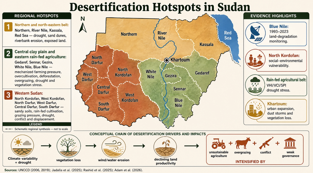
Land degradation and desertification are widespread across Sudan’s various ecological and agricultural zones, and cannot be attributed to a single region or factor. According to national documents, historical pressures are concentrated in the northern and north-eastern states, (Northern, River Nile, and Kassala) due to drought, dune encroachment, and vegetation degradation; in the central clay plain and eastern agricultural regions (Gedaref, Sennar, Gezira, and White Nile) due to intensive agriculture, deforestation, grazing, and changes in land-use; and in western Sudanese states (North and West Kordofan and North, West, and Central Darfur) due to the fragility of sandy soils, rain-fed agriculture, grazing pressure and rainfall variability (UNCCD, 2006; UNCCD, 2019).
More recent studies identify more specific spatial hotspots. For example, Blue Nile State revealed an increase in land degradation categories between 1993–2023, while a study in North Kordofan showed that some framing households were highly vulnerable from a socio-ecological perspective, due to weak land use security and limited access to credit and resources. Remote sensing analyses in rain-fed agricultural areas also revealed variations in drought, heat stress, and vegetation health in Gedaref, Blue Nile and Sennar compared to other regions (Jadalla, Oluwasemire, and Elmobarak, 2025; Rashid et al., 2025; Adam et al., 2026).
Therefore, hotspots in Sudan should be defined as areas where indicators of drought, declining vegetation productivity, soil degradation, agricultural or pastoral pressure, social vulnerability, and conflict converge. It is also important to distinguish between the risk of desertification, indicators of degradation, and proven cases of desertification. A high drought index or low vegetation cover alone is insufficient to prove desertification; these factors must be supported by data on land productivity and soil characteristics, and change in land use.The map below illustrates the spatial distribution of desertification hotspots across Sudan, highlighting areas that are particularly vulnerable to land degradation and desertification.
Environmental and Socio-economic Impacts :
Land degradation, desertification and drought in Sudan have affected ecosystems, agricultural and pastoral activities, as well as the livelihoods of local communities. This is evident in decreased productivity in certain agricultural land areas and rangelands, reduced vegetation density, increased soil erosion, and heightened pressure on water and land resources. A study conducted in the Blue Nile region confirmed spatial and temporal changes in land degradation indicators during the period 1993–2023. This study showed an increase in some categories of degradation and a decrease in areas classified as non-degraded (Jedallah, Oluwasmir, and Al-Mubarak, 2025; United Nations Convention to Combat Desertification, 2019).
The loss of vegetation cover and the degradation of rangelands has reduced the area, variety, and density of forage, forcing pastoral communities to alter their migration routes in search of water and grazing land. This has intensified competition for resources, particularly when coupled with drought, displacement, weak land management and conflict resolution mechanisms. Rangeland degradation has also led to livestock losses and reduced livelihoods. However, estimating the number of animals killed or the extent of the losses requires independent statistical data for each region and time period (UNCCD, 2006; UNCCD, 2019; CEOBS, 2025).
The decline in vegetation cover increases soil surface exposure, making it more susceptible to wind and water erosion. This contributes to sand encroachment and increased dust storms in some arid and semi-arid regions. This impacts agricultural lands, rangelands, and settlements. However, identifying villages or areas buried or abandoned due to sand requires a spatial study or a site-specific field report (UNCCD, 2006).
The armed conflict that began in April 2023 exacerbated existing pressures by displacing farmers and pastoralists, restricting access to land and water, and disrupting supply chains. This has weakened the maintenance of agricultural and water infrastructure. The result was damage to farmland and production systems, disruption to agricultural operations, and difficulty accessing inputs and markets. The Gezira Scheme was also affected by these pressures, particularly due to disruptions in irrigation management and maintenance, difficulty accessing fields, and the impact on the continuity of agricultural production and the livelihoods of local communities. Furthermore, the conflict hindered environmental monitoring and response to droughts and floods affecting households’ access to resources, markets, and livelihoods. (CEOBS, 2025; IMPACT Initiatives, 2026; World Vision Canada, 2026).
Farming communities have been affected by erratic rainfall patterns, droughts, floods, damaged infrastructure, shortages of agricultural supplies, and limited market access. These impacts are more pronounced in rain-fed agriculture. A study in North Kordofan demonstrated varying levels of environmental vulnerability among farming households, linking exposure to factors such as land tenure security, access to credit, livestock ownership, household size, and educational attainment (IMPACT Initiatives, 2026; Rashid et al., 2025).
The decline of arable land, rangelands, and water resources, coupled with drought, displacement, and changing land-use patterns, has increased competition and friction between farming and pastoral communities in some areas, such as Darfur and Kordofan. This is particularly the case where resource management and conflict resolution mechanisms are weak. However, conflicts should not be reduced to purely environmental ones; the Sudanese conflict is multifaceted, with political, military, economic, social, and environmental factors intertwined (UNCCD, 2019; CEOBS, 2025).
Environmental impacts overlap between economic and social impacts. A decline in agricultural and pastoral production can lead to reduced income, increased food insecurity, greater displacement and higher reliance on aid. Furthermore, weakened basic services, higher input costs and disrupted markets can exacerbate the vulnerability of affected communities. However, not all of these outcomes should be attributed solely to desertification; conflict, poverty, and service degradation are independent and interacting factors that also influence humanitarian outcomes (IMPACT Initiatives, 2026; Rashid et al., 2025; World Vision Canada, 2026).
Sudanese Case Studies :
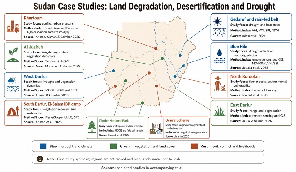
Khartoum: Urban and peri-urban areas in Khartoum are affected by vegetation loss, urban sprawl, waste accumulation, and conflict-related disturbances. A study of the Sunut Protected Forest demonstrates that conflict and land-use change have contributed to vegetation degradation within a riverine urban ecosystem (Ahmed, Osman, and Czimber, 2026).
Gadarif: Gadarif is a model of mechanized rainfed agriculture and is affected by drought, heat stress, and rainfall variability. A recent study showed that areas in Gadarif are relatively prone to drought, and that VHI, VCI, and SPI indices are useful for monitoring vegetation and crop status (Adam et al., 2026; Maysoon, 2024).
Gezira: Gezira State is a model of irrigated agriculture, particularly the Gezira Scheme. NDVI analyses showed a marked change in vegetation cover during the period 2016–2024, associated with rainfall, political instability, and conflict. Soil degradation or salinization should not be generalized throughout the Sudan project without specific field studies (Anwer, Mohamed and Hassan, 2025; Ibrahim, 2020).
Sennar and Al-Suki: Environmental pressures in Sennar are linked to changes in land use, agriculture, irrigation, and rainfall variability. The Al-Suki area falls within the agricultural and irrigation zones that require an independent assessment of irrigation and drainage efficiency and vegetation cover. No recent studies are currently available to generalize quantitative results to the entire state (UNCCD, 2006; UNCCD, 2019).
Blue Nile: A spatial study for the period 1993–2023 showed an increase in land degradation categories and a decrease in areas classified as non-degraded, with degradation associated with drought, changes in vegetation cover, and land surface characteristics (Jadalla, Oluwasemire and Elmobarak, 2025).
White Nile: Drought analyses in rainfed agricultural areas have shown that the White Nile, along with some northern and central regions, was more vulnerable to drought and heat stress than the southern and irrigated areas (Adam et al., 2026). Degradation pressures in some areas are also linked to grazing, rainfall variability, and land-use changes (UNCCD, 2006; UNCCD, 2019).
Kassala, Red Sea, Northern, and River Nile states: These states represent the northern and northeastern belt, where land degradation risks are linked to drought, dune encroachment, riverbank erosion, and loss of vegetation cover around water bodies and water points. This picture is primarily based on historical national documents and therefore needs to be updated with remote sensing data and recent field measurements (UNCCD, 2006; UNCCD, 2019). North Kordofan: Field research in the North Kordofan reveals varying levels of social and environmental vulnerability among farming households, linked to land tenure security, access to credit, livestock ownership, family size, and education level. The situation demonstrates that limited economic resources exacerbate the difficulty of adapting to drought and land degradation (Rashid et al., 2025).
West Kordofan: The main environmental pressures are exacerbated by reliance on rain-fed agriculture, intensive grazing, fragile sandy soils, and erratic rainfall. The region is classified as a historically affected rangeland and agricultural degradation zone; however, estimating the rate of degradation requires updated spatial and field studies (UNCCD, 2006; UNCCD, 2019).
East Darfur: The study on East Darfur shows that rangeland degradation is linked to erratic rainfall, overgrazing, and agricultural expansion, impacting vegetation density and the availability of fodder and water resources for pastoral communities (Jali and Abdullah, 2026).
.West Darfur: A study based on NDVI and SPEI analysis showed that vegetation cover declined during sWest Darfur: A study based on NDVI and SPEI analysis showed that vegetation cover declined during some drought years, particularly in 2005 and 2010, followed by periods of recovery in years characterized by increased rainfall and reduced drought intensity. This highlights that recovery in some years does not necessarily mean that the risks of drought and desertification have disappeared (Ahmed and Czimber, 2025).
North Darfur: Long-term analyses of the SPEI index indicate a relatively positive trend in water balance during some periods; however, severe drought events continue to occur. Rangelands and rain-fed agricultural systems are also affected by displacement, increasing pressure on natural resources, and rainfall variability (Ahmed and Czimber, 2026; UNCCD, 2019).
Central and South Darfur: These areas illustrate the convergence of drought, rangeland degradation, rain-fed agriculture, displacement, and conflict. However, a study conducted in the Al-Salam camp area of South Darfur reported an improvement in vegetation cover and a reduction in barren land during 2017–2023, which was associated with reforestation, water harvesting, increased rainfall, and the participation of internally displaced persons (Ahmed et al., 2026).
Dinder National Park: A study of Dinder National Park found that fire frequency was associated with changes in certain soil chemical properties, including slight decreases in organic carbon and nitrogen. However, this finding is specific to the protected ecosystem and study site and should not be generalized to other areas of Sudan (Elmardi et al., 2025).
 Existing policies/institutions:
Sudan has several frameworks, policies, and institutions related to combating desertification, managing drought, and adapting to climate change. These include the National Program to Combat Desertification, the National Drought Plan, voluntary commitments within the Land Degradation Neutrality (LDN) framework, and the National Adaptation to Climate Change Action Programme (NAPA). These frameworks emphasize the importance of integrated land, water, and rangeland management, the restoration of degraded ecosystems, the improvement of monitoring and early warning systems, and the enhancement of community participation.
Sudan formally acceded to the United Nations Convention to Combat Desertification (UNCCD), signing the Convention on October 15, 1994, and ratifying it on November 24, 1995, thus becoming a party to the Convention under the United Nations Treaty Organization. In principle, Sudan is committed to participating in implementing the Convention’s objectives, preparing national reports, developing programs to combat desertification and land degradation, and engaging in international and regional cooperation on drought, land restoration, and resilience building. Nationally relevant bodies include the Higher Council for Environment and Natural Resources and relevant ministries. These bodies, within their respective mandates and national frameworks, are responsible for monitoring drought and floods, collecting data, managing water and rangelands, providing agricultural extension services, and coordinating disaster response.
t the international level, the Food and Agriculture Organization (FAO) supports efforts to restore drylands, build capacity, monitor and evaluate resources, and share knowledge. The United Nations Development Programme (UNDP) focuses on strengthening national resilience, rehabilitating rangelands and forests, harvesting water, and improving agricultural practices in fragile areas. Sudan can also participate in research and technical cooperation with regional and international organizations such as UNESCO, the Arab Center for the Studies of Arid Zones and Dry Lands (ACSAD), the International Fund for Agricultural Development (IFAD), and the International Center for Agricultural Research in the Regions (ICARDA).
Challenges:
Conflict is exacerbated by climate change, poverty, weak governance, and competition for resources.
Weak coordination among institutions responsible for land, water, agriculture, and rangelands.
Overlapping jurisdictions, limited spatial and field data, and poor maintenance of monitoring stations.
Funding shortages, political instability, and armed conflict.
Large reliance on rain-fed agriculture and natural rangelands.
Continued unsustainable practices such as overgrazing, deforestation, and unplanned agricultural expansion.
Proposed solutions and recommendations:
Prioritize combating desertification, drought, and land degradation as national priorities within recovery and development plans.
Unify monitoring and early warning systems and translate scientific data into proactive decision-making.
Expand land and rangeland restoration and promote sustainable water and agricultural management.
Strengthen land governance, tenure security, and reduce resource conflicts.
Mobilize and direct sustainable financing to the most vulnerable regions and communities.
Promote scientific research and knowledge transfer, support innovation, and utilize research findings and modern technologies in land restoration and drought adaptation.
Enhance community participation and institutional coordination to ensure the sustainability and effectiveness of interventions.
References:
- Adam, A.A. et al. (2026) ‘Satellite-based drought assessment in major Sudan’s mechanized rain-fed agriculture’, Scientific Reports, 16, article 18650. Available at: https://www.nature.com/articles/s41598-026-49618-5 .
- Ahmed, A. and Czimber, K. (2026a) ‘Multi-decadal drought variability and regime dynamics in Darfur, Sudan (1981–2025)’, Journal of Arid Environments, 237, article 105708. Available at: https://doi.org/10.1016/j.jaridenv.2026.105708 .
- Ahmed, A. and Czimber, K. (2026b) ‘Multi-scale drought-vegetation relationships in the Jebel Marra Highlands, Sudan: evidence from Landsat NDVI time series, SPEI, and BFAST analysis’, Frontiers in Forests and Global Change, 9, article 1879552. Available at: https://doi.org/10.3389/ffgc.2026.1879552 .
- CEOBS (2025) ‘The environmental costs of the war in Sudan’. Conflict and Environment Observatory, 21 May. Available at:https://ceobs.org/the-environmental-costs-of-the-war-in-sudan/
- del Barrio, G., Sanjuán, M.E. and Martínez-Valderrama, J. (2026) ‘A framework of conceptual principles for addressing desertification’. In: The Labyrinth of Desertification: Sixteen Case Studies in Spain. Cham: Springer, pp. 1–19. Available at: https://doi.org/10.1007/978-3-032-09648-7_1 .
- Elmardi, M.E.M., Hassan, M.M.A., Ibrahim, M.E.A., Hamid, A.A. and Siddig, A.A.H. (2025) ‘Assess the Role of Fire Frequency on Some Soil Chemical Properties in Dinder National Park (DNP), Sudan Using Geospatial Technology’, Journal of Geoscience and Environment Protection, 13(10), pp. 1–24. Available at: https://doi.org/10.4236/gep.2025.1310002.
- European Space Agency (ESA) (2024) ‘Land degradation monitoring through Earth observation: ESA at UNCCD COP16’. EO Science for Society. Available at: https://eo4society.esa.int/2024/12/20/land-degradation-monitoring-through-earth-observation-esa-at-unccd-cop16/ .
- FEWS NET (2025) ‘Historic dry rainy season triggers alarm for deepening food insecurity in the Horn’. East Africa Alert, 23 December. Available at: https://fews.net/east-africa/alert/december-2025-0.
- Food and Agriculture Organization of the United Nations (FAO) (2026) ‘Land overview’. Land, Soil and Water. Available at: https://www.fao.org/land-water/land/overview/en.Food and Agriculture Organization of the United Nations (FAO) (2021) Action Against Desertification: Sudan.
- Ibrahim, Y.A. (2020) ‘Complex adaptive system approach for improved irrigation management: The case of the Gezira Scheme in Sudan’, Irrigation and Drainage. Available at: https://doi.org/10.1002/ird.2516
- IMPACT Initiatives (2026) Sudan Climate Analysis in the Context of Conflict (December 2025). Available through ReliefWeb at:https://reliefweb.int/report/sudan/sudan-climate-analysis-context-conflict-december-2025 .
- Intergovernmental Panel on Climate Change (IPCC) (2022) Climate Change 2022: Impacts, Adaptation and Vulnerability: Contribution of Working Group II to the Sixth Assessment Report of the Intergovernmental Panel on Climate Change. Cambridge: Cambridge University Press. Available at: https://www.ipcc.ch/report/ar6/wg2/.
- Intergovernmental Authority on Development (IGAD) (2025) ‘Strengthening Food Security and Nutrition in the IGAD Region’. Available at: https://igad.int/strengthening-food-security-and-nutrition-in-the-igad-region/ .
- Jadalla, F., Oluwasemire, K.O. and Elmobarak, A.E. (2025) ‘Modelling the spatial distribution of drought effects on land degradation in the Blue Nile Region, Sudan’, Journal of Applied and Natural Science, 17(3), pp. 1345–1361. Available at: https://doi.org/10.31018/jans.v17i3.6608
- Jali, Y.A.N.A. and Abdullah, A.I.M. (2026) ‘Geospatial analysis of the dynamics of rangeland resource degradation using remote sensing techniques and geographic information systems: a spatio-temporal study in East Darfur’, Ibn Khaldoun Journal for Studies and Researches, 6(4). Available at: https://doi.org/10.56989/mj6bkw20 .
- Khalifa, A.E.S.O. (2025) ‘The role of rehabilitation and conservation of vegetation cover in combating desertification, Shikan Locality, North Kordofan, Sudan’. University of Sirte Repository. Available at: http://dspace.su.edu.ly/handle/123456789/3717.
- Madani, A.A. and Musa, M.A.M. (2026) ‘Assessment of the Sources and Pathways of Conflict-Related Soil Contamination in Sudan: An Analytical Study of Experts’ and Specialists’ Awareness’, Humanities & Natural Sciences Journal, 7(5), pp. 368–378. Available at: https://doi.org/10.53796/hnsj75/19.
- Maysoon, A., 2024. Impact of Climate Change and Land Use/Land Cover Dynamics on Small-scale Farming System in Gedaref State, Sudan. PhD thesis. University of Nairobi.
- Mercy Corps (2024) Sudan Crisis Analysis: Remote Sensing to Anticipate Agriculture Conditions: South Kordofan State. March. Available at:https://www.mercycorps.org/sites/default/files/2024-03/sudan-south-kordofan-remote-sensing-march-2024.
- Mwesige, F.F. et al. (2025) ‘The extent and distribution of salt-affected soils in sub-Saharan Africa from 1970 to the present: a review of the current state of knowledge’, Frontiers in Soil Science, 5, article 1571243. Available at: https://doi.org/10.3389/fsoil.2025.1571243 .
- Potsdam Institute for Climate Impact Research (PIK) (2024) Stepping back from the precipice: Transforming land management to stay within planetary boundaries. Special report prepared for UNCCD COP16. Available at :https://www.unccd.int/resources/reports/stepping-back-precipice-transforming-land-management-stay-within-planetary .
- Prăvălie, R., Borrelli, P., Panagos, P., Ballabio, C., Lugato, E., Chappell, A., Miguez-Macho, G., Maggi, F., Peng, J., Niculiță, M., Roșca, B., Patriche, C., Dumitrașcu, M., Bandoc, G., Nita, I.-A. and Birsan, M.-V. (2024) ‘A unifying modelling of multiple land degradation pathways in Europe’, Nature Communications, 15, article 3862. Available at: https://doi.org/10.1038/s41467-024-48252-x (Accessed: 20 August 2026 ).
- Rashid, R., Zhou, J., Kiptum, G.K. and Shah, A.A. (2025) ‘Assessing the risk of environmental decline for farmers: key factors and regional trends in North Kordofan State, Sudan’, International Journal of Agricultural Sustainability, 23. Available at: https://doi.org/10.1080/14735903.2025.2569156 .
- Roy, P., Pal, S.C., Chakrabortty, R., Chowdhuri, I., Saha, A., Ruidas, D., Islam, A.R.M.T. and Islam, A. (2024) ‘Climate change and geo-environmental factors influencing desertification: a critical review’, Environmental Science and Pollution Research, 31, pp. 20343–20361. Available at: https://doi.org/10.1007/s11356-024-32432-9 .
- United Nations (2024) ‘Three-quarters of Earth’s land became permanently drier in last three decades: UN’. United Nations Sustainable Development. Available at: https://www.un.org/sustainabledevelopment/blog/2024/12/press-release-three-quarters-of-earths-land-became-permanently-drier-in-last-three-decades-un/ .
- United Nations Convention to Combat Desertification (UNCCD) (n.d.) ‘Land Degradation Neutrality’. Available at: https://www.unccd.int/land-and-life/land-degradation-neutrality/overview (Accessed: 20 August 2026 ).
- United Nations Convention to Combat Desertification (UNCCD) (2024a) Investing in Land’s Future. Bonn: UNCCD. Available at: https://www.unccd.int/sites/default/files/2024-12/58587%20UNCCD_FNA_SDM_web.pdf (Accessed: 20 August 2026 ).
- United Nations Convention to Combat Desertification (UNCCD) (2024b) The Global Threat of Drying Lands: Regional and Global Aridity Trends and Future Projections. Bonn: UNCCD. Available at: https://www.unccd.int/resources/reports/global-threat-drying-lands-regional-and-global-aridity-trends-and-future.
- United Nations Convention to Combat Desertification (UNCCD) (2026) Addendum to the Good Practice Guidance: SDG Indicator 15.3.1, Proportion of Land That Is Degraded over Total Land Area. Version 2.0. Bonn: UNCCD. Available at: https://www.unccd.int/resources/publications/addendum-good-practice-guidance-sdg-indicator-1531-proportion-land-degraded .
- Wang, W. and Wang, H. (2025) ‘Rethinking drought definition and classification’, Water Science and Engineering, 18(2), pp. 125–128. Available at:https://doi.org/10.1016/j.wse.2025.04.002 .
- World Bank (2025) ‘Restoring land and livelihoods in Niger’s Tahoua Region’. Sahel RESILAND Programme, 14 August. Available at:https://www.worldbank.org/en/programs/sahel-resiland/brief/restoring-land-and-livelihoods-in-niger-s-tahoua-region .
- World Bank (1979) The Gezira Irrigation Scheme in Sudan: Objectives, Design and Performance. Washington, DC: World Bank. Available at: https://documents.worldbank.org/en/publication/documents-reports/documentdetail/377141468778504847 .
- World Vision Canada, 2026. The Hollowed Earth: How the Prolonged Conflict in Sudan is Affecting Children and Their Families. Available at:https://www.wvi.org/Hollowed-Earth-Report .
 Arabic
  English