
Morphometric analysis of Igouzoulen basin (Western High Atlas, Morocco)
Ahmed ait ettajer¹, Mohamed rizki², Mostapha ouadrim³
¹ Doctoral research student, Doctoral Training Center for Environmental Management and Sustainable Development, Faculty of Arts and Humanities, Mohammed V University, Rabat. ahmed.aitettajer@um5r.ac.ma
² Research professor, Societies, Soil, History and Heritage Laboratory. Faculty of Literature and Human Sciences, Mohammed V University in Rabat.
³ Rseach professor, Dynamics of Spaces and Societies Laboratory (LDES), Faculty of Literature and Human Sciences Mohamadia, Hassan II University of Casablanca.
DOI: https://doi.org/10.53796/hnsj66/5
Arabic Scientific Research Identifier: https://arsri.org/10000/66/5
Volume (6) Issue (6). Pages: 44 - 55
Received at: 2025-05-07 | Accepted at: 2025-05-15 | Published at: 2025-06-01
Abstract: Morphometric analysis involves the precise measurement and mathematical scrutiny of the physical features of landscapes. Its importance lies in its pivotal role in deciphering the geohydrological attributes of a drainage basin, particularly in correlation with the topographical traits and the patterns of water flow within the terrain. The objective of this study was to numerically assess the morphometric features of the Igouzoulen watershed, aiming to facilitate the effective implementation of soil and water conservation practices. By quantifying the various morphological parameters within the watershed, the research endeavors to provide a solid foundation for informed decision-making in sustainable land management, thereby contributing to the successful execution of conservation strategies tailored to the specific characteristics of the Igoiuzoulen region.
Keywords: GIS. Morphometry, Aster Dem, Igouzoulen Basin, Western Hight Atlas, Morocco
INTRODUCTION
The characteristic of drainage basins depends upon the slope, regional tectonics, geology of the catchment area, and aerial climate (Singh et al., 2019). These characteristics interact with each other to determine the morphology of the river basin. Morphometric analysis of watersheds is the best method to identify the relationship of various aspects in the area (Sukristiyanti et al., 2018; Mazahir et al., 2022). In geomorphology, morphometry is a quantification of morphology (Sukristiyanti et al., 2018). Morphometric characteristics help explain the shape of the river basin and the characteristics of the water network. And also these morphometric descriptors represent relatively simple approaches to describe basin processes and to compare basin characteristics (Mesa, 2006).
This is an important aspect, considering that this study will establish an accurate database for the Igouzoulen Basin. The region is significant due to the presence of important human settlements. The aim is to compare it with the rest of the neighboring river basins. The current study establishes a link between surface morphometry and subsurface geology within a drainage basin. The goal is to generate valuable information for effective basin management, utilizing geographic information systems (GIS).
STUDY AREA
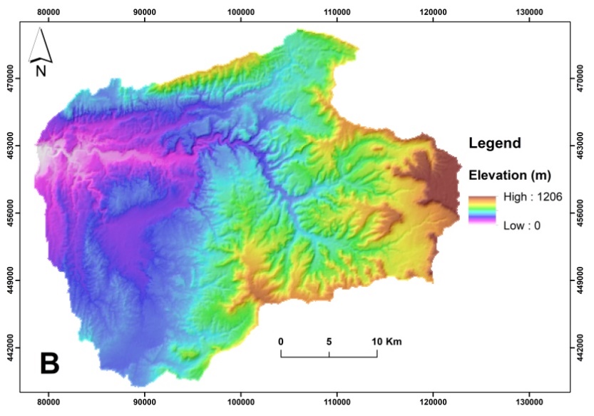
Igouzoulen River basin lies in a western high atlas, East Southwest of Morocco, and is bounded between 9˚52’E to 9˚67’E longitudes and 30˚07’N to 31˚11’N latitudes that cover a geographical area of about 1035 km² (Figure1). The Igouzoulen river flows in the East-west direction with a gentle to moderate slope that ranges 0˚ – 38˚ and has a length of about 52.41 km. The maximum elevation basin ranges from 1206 m in the east to 5 m in the west. The Igouzoulen River basin includes several sub-basins )amelmim sub- basin, tassrassart sub-basin, ighzer ou rhal sub- basin(.The drainage of this basin is external as it empties into the Atlantic Ocean through its main tributary, the Oued Igouzoulen. This river is a seasonal river that flows in the western Atlas terrain of Ait Daoud.
There are multiple climatic stations in a western high atlas. Tamanar station is located within the river basin under study. The average maximum temperature of the hottest month (July or August) typically reaches 36°C, While the average minimum reaches 7°. Average precipitation reaches 313 mm per year. The humid season of the year spans from November to March. The month of October had a prolonged period of high humidity, extending beyond the typical peak in July and August (F. El Wahidi, 2013, p 38). The vegetation cover is characterized by the prevalence of “Argania Spinosa”, which is most abundant in the southwestern regions of Morocco, there are two other types: “Quercus suber” or “ cork oak “ and “ juniper”.
The highest elevations in the basin, reaching 1200 meters, are located at its top and gradually slope toward the Atlantic Ocean.
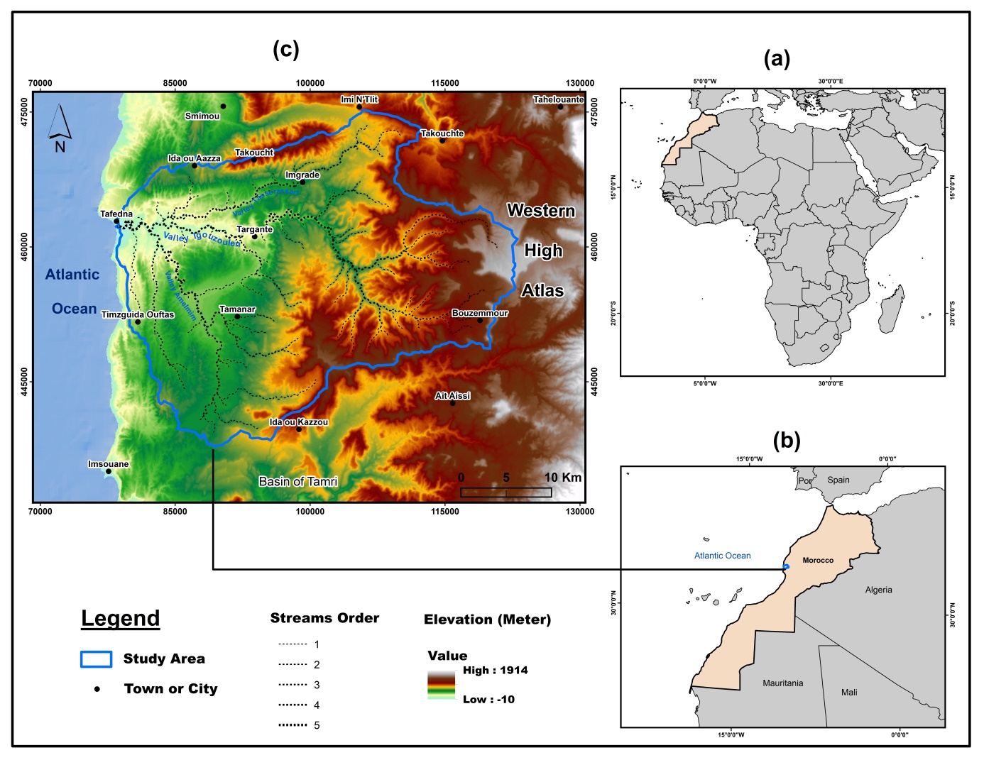
Figure 1: Location map of the study area, (a) Morocco’s location on the African continent (b) Location of the river basin in Morocco,(c) Igouzoulen basin within the western high atlas.
The geological foundation of the Western High Atlas is primarily composed of ancient basement rocks, clearly visible except at the westernmost end of the High Atlas (El ouahidi,2008). It is overlain by Triassic facies with a thickness ranging from 2500 to 5000 meters (Smiej et al., 2010). At the bottom of the Igouzoulen Basin, it reaches a depth of 500 meters (Charton et al., 2021). It is composed of red salt clay and greenish diorite basalt and is covered by continental and near-marine Cretaceous and Jurassic sediments with a thickness of up to 3000 meters (El ouahidi,2008).
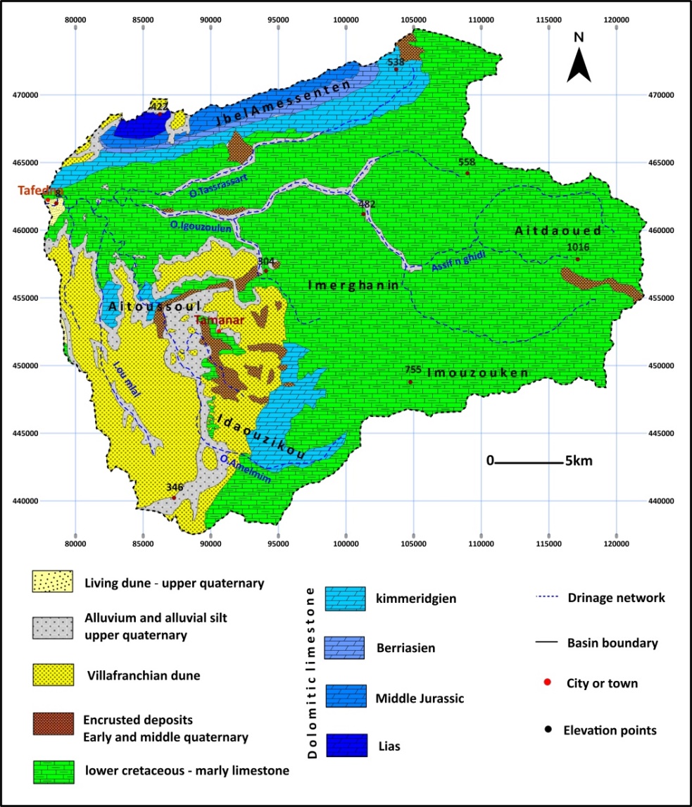
Figure 2: Types of rocks in the Igouzoulen River basin
MATERIALS AND METHODS
The area, altitude, volume, slope, profile, and texture of landforms are the principal parameters to be studied in a basin under morphometric study (Rai et al., 2019). In this study, digital elevation modeling (DEM) is used to determine the boundaries of the river basin and the water network and to extract elevation, slope, and orientation maps in ArcGIS (Arc Map 10.3) software by using merchich datum, and coordinate system of South morocco. Geological maps were also relied upon (tamanar leaf 1/100000, Taghazout leaf 1/100000, Khemiss Meskala leaf 1/100000) To comprehend the geological formations, understand their structure, and establish a correlation with the surface topography and characteristics of the water network. The motphometrique parameters were divided into three categories: Areal aspect, Relief aspect, and Linear aspect (Potter, 1957) (Table 1).The data in the first category includes basin perimeter, basin area, basin length, basin width, form factor, circularity ratio, drainage density, drainage texture, and length, of overland flow. Those of the second category are maximum elevation, degree elevation, degree of slope, basin relief, and relief ratio. The linear aspects are stream order, stream numbers, stream length, stream ratio, and bifurcation ratio.
|
Morphometric parameters |
Methods |
Units |
L’auteur |
|
|
Areal aspect |
Basin Perimeter P |
GIS software – Raster Calculator |
Km |
Schumm (1956) |
|
Basin Area A |
GIS software – Raster Calculator |
Km² |
Schumm (1956) |
|
|
Basin Length Lb |
GIS software – Raster Calculator |
Km |
Schumm (1956) |
|
|
Basin Width (Wb) |
Km |
Schumm (1956) |
||
|
Form Factor (Rf) |
Km |
Horton (1932) |
||
|
Circularity ratio (Rc) |
km |
Strahler (1964) |
||
|
Elongation ratio (Re) |
)) |
km |
Schumm (1956) |
|
|
Drainage density (Dd) |
km/ Km2 |
Horton (1932) |
||
|
Drainage texture (T) |
km-1 |
Smith (1950) |
||
|
Length of overland flow (Lo) |
km |
Horton (1945) |
||
|
Relief aspect |
Maximum Elevation (H) |
GIS software – Raster Calculator |
m asl. |
Schumm (1956) |
|
Minimum Elevation (h) |
GIS software – Raster Calculator |
M asl |
Schumm (1956) |
|
|
Degree of Slope (S) |
GIS software – Raster Calculator |
m |
Burrough (1986) |
|
|
Basin Relief (R) |
m |
Strahler (1957) |
||
|
Relief ratio (Rr) |
m |
Schumm (1956) |
||
|
Linear aspect |
Stream Order (Lo) |
Hierarchical rank |
m |
Strahler (1957) |
|
Stream numbers (Nu) |
m |
Horton (1945) |
||
|
Mean stream length (Lsm) |
km |
|||
|
Stream length (Lu) |
Length of the stream |
m |
Horton (1945) |
|
|
Stream length ratio (Lur) |
m |
Horton (1945) |
||
|
Bifurcation ratio (Rb) |
m |
Strahler (1964) |
Table 1: Methods of calculation of different Morphometric parameters and their observed values for the Igouzoulen River, western high atlas, east southwest of MoroccoRESULTS AND DISCUSSION
1. Areal morphometric parameters of Igouzoulen and Ribb watershed
real aspects include different morphometric parameters, like basin perimeter p, basin area A, basin length Lb, basin width wb, form factor Rf, Circularity ratio Rc, drainage density Dd, drainage texture T, length of overland flow Lo. The areal characteristics of the catchment estimated in this study are presented in Table 1.
1.1.bassin area (A)
A drainage basin area is defined as the area of any land where rainfall collects and empties into a single or common outlet like a river. The area of the Igouzoulen River basin as calculated is 1035,52 km2.
1.2.Basin perimeter (P)
The basin perimeter delineates the external boundary of the watershed, encapsulating its entire area. It is quantified along the divides separating neighboring watersheds and serves as a potential gauge for assessing the size and configuration of the watershed. The GIS platform was employed to compute the basin perimeter of the study area, yielding a measurement of 156,29 km.
1.3 form factor (Rf)
Horton (1945) defined the form factor (Rf) as the ratio between basin area (A) and the square of basin length (Lb2). This ratio deals with the shape of the basin and is also related to drainage texture and relief of the basin. The zero value indicates a highly elongated shape and one indicates the circular shape of the basin (Singh et al., 2019). The closer the form factor of the river basin is to zero, the more inconsistent and irregular the basin is, If it is close to 1, it indicates that the river basin takes a circular shape. In the Igouzoulen Basin, the form factor reached 1. 35, meaning that the speed of transforming rainwater into torrents is moderate.
1.4.circularity ratio (Rc)
The circulatory ratio is expressed as the ratio of the basin area (A) and the area of a circle with the same perimeter as that of the basin (Kanhaiya et al., 2019; Sukristiyanti et al., 2018). Runoff in circular shape basins gets more time to stay, Therefore, the circular-to-elongate basin is inversely related to the character of movement (rapid or slow) of run-off to outlet and infiltration (Sigh et al., 2019). The closer this indicator is to 1, the shape tends to be circular, and the further away it is from 1, the more it tends to elongate. The closer the shape of the basin becomes to the roundness, the faster the tributary water accumulates, threatening the areas where residential communities are located. These are further subjected to lithology, slope, and land cover of the basins or sub-catchments (Singh et al., 2019). The computed circulatory ratio for the study area is 0.53, which indicates the elongated shape of the studied river basin.
1.5.drainage density (Dd)
The drainage density (Dd) is the stream length per unit area in the basin area (Arthur N . Strahler, 1957; Chorley, 1995; Strahler, 1958). drainage density is related to landscape dissection, climate and vegetation, soil and rock properties, and landscape evolution processes (Asfaw and Workineh, 2019). In addition, drainage density reflects the infiltration capacity of the land (Yunus et al., 2014). Igouzoulen has a drainage density of 2,56 km/km2. which is a relatively low value and indicates the basin area is highly permeable subsoil material with low relief and vegetative cover (Mazahir et al., 2022). And the nature of the rocks in the river basin. A large percentage of the basin’s rocks are of calcareous and clay facies and date back to the Lower Cretaceous; And dolomitic lime, which is found high on Mount Amesseten(Figure 2). These rocks are characterized by their fragility, as they are largely targeted by chemical erosion (dissolution).
1.6.Drainage texture (T)
Drainage texture (T) is a valuable concept of geomorphology and reflects the basic lithology, infiltration capacity, and relief of the topography (Mazahir et al., 2022; Rai et al., 2019). And also climate, and vegetation density (Mazahir et al., 2022). It is the total number of stream segments of all orders in a basin per perimeter of the basin (Chorley, 1995). Low drainage density results in coarse drainage texture while high drainage density leverages fine drainage texture which depends on infiltration capacity of bedrock or mantle rock (Kulkarni, 2013). A T value lesser than 4.0 signifies the texture is coarse, a T value in the range of 4.0 – 10.0 signifies the texture is intermediate, a T value in the range of 10.0 – 15.0 signifies the texture is fine and a T value beyond 15.0 signifies the texture as ultra –fine (Vignesh et al.,2012). The T value of the Igouzoulen River basin is 0,15, which suggests the texture of the drainage basin is coarse.
1.7.Length, of overland flow (Lo)
The length of overland flow is the length of water over the ground before it gets concentrated into certain stream channels (Sukristiyanti et al., 2018). This term refers to the distance that rainwater travels before it gets concentrated into definite stream channels(Chorley, 1995). The calculated value of Lo for the study area is 0.36 (Table 2 ).
|
Basin area A |
Basin length Lb |
basin width wb |
form factor Rf |
circularity ratio Rc |
drainage density Dd |
Drainage texture T |
length, of overland flow Lo |
|
|
156,29 |
1035,52 |
52,41 |
19,75 |
1,35 |
0.53 |
2,56 |
0,15 |
0,36 |
Table 2: Linear Morphometric Characteristics of River Catchment
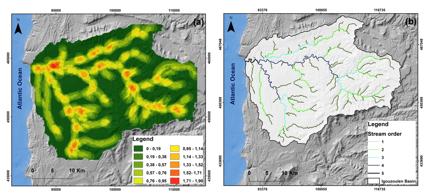
Figure 3: drainage density (a) and stream order (b) of the Igouzoulen basin
2. Linear morphometric parameters of Igouzoulen and Ribb watershed
The linear aspects include the stream order (Nu), stream length (Lu), mean stream length (Lsm), stream length ratio (RL), and bifurcation ratio (Rbm). and are discussed below:
2.1. Stream Order (Lo)
Stream ordering (Nu) is the first step in the drainage basin analysis (Kanhaiya et al., 2019). In the current investigation, the stream orders are established according to the classification method outlined by Strahler (1964). “Stream order” is the parameter that is used to describe the hierarchy of the streams, a positive whole number that indicates the branching level of any river (Mazahir et al., 2022). The watershed exhibits five stream orders, with the 5th order representing the highest order (refer to Figure 3 b)
2.2. Stream numbers (Nu)
The stream number is the count of stream segments across different orders. A total 149 of streams were identified out of which 75 were found to be in the first order, 35 were in the second order, 16 were in the third order,20 were in the fourth order and 3 were in the fifth order (Table 3). The higher amount of stream order indicates lesser permeability and infiltration (strahler 1964).
2.3. Mean stream length (Lsm)
Mean stream length (Lsm) reveals the characteristic size of components of a drainage network and its contributing surfaces (Rai et al., 2017). Mean Stream Length is calculated as the ratio of total stream length and the number of streams in any particular order (Pareta and Pareta, 2011). contains the order-wise mean stream length data. Mean stream length for 1st order: 2.68 , 2nd order: 2.80, 3rd order: 2.88, 4th order: 2.73 and 5th order: 2.12 (Table 3)
2.4. Stream length (Lu)
The length of the stream (Lu) is a crucial hydrological parameter for any river basin, as it reveals the surface runoff characteristics of relatively shorter drainage lengths and the features of larger gradient areas with finer textures. Table 3 includes stream length data organized by order, and the corresponding details are provided below:
- Total Stream Length: 405,69 km
- Total Stream Length for 1st order: 200,67km, 2nd order: 98,11km, 3rd order: 46,02km, 4th order: 54,54km, and 5th order: 6,35km
2.5. Stream length ratio (Lur)
Stream length ratio (RL) may be defined as the ratio of the mean length of an order to the next lower order of stream segment (Ali and Khan, 2013). The stream length ratio within the Igouzoulen River basin (as indicated in Table 1) ranges from 0.12 to 0.49. After calculating the stream length ratio, it has been observed that the ratio has changed from one order to another, which is shown in Table 3 Changes of ‘Lur’ from one order to another order signifying their late youth stage of geomorphic development (Rai et al., 2017; Singh et al., 2014).
2.6. Bifurcation ratio (Rb)
|
stream count (Nu) |
stream length (Lu) |
Mean stream length (Lsm) |
Stream length ratio (Lur) |
Bifurcation ratio (Rb) |
|
|
0 |
75 |
200,67 |
2,68 |
– |
2,14 |
|
1 |
35 |
98,11 |
2,80 |
0,49 |
2,19 |
|
2 |
16 |
46,02 |
2,88 |
0,47 |
0,80 |
|
3 |
20 |
54,54 |
2,73 |
1,19 |
6,67 |
|
4 |
3 |
6,35 |
2,12 |
0,12 |
– |
|
Totale |
149 |
405,69 |
13,20 |
– |
– |
Table 3: Stream order, stream number, stream length, stream length ratio and bifurcation ratio of Igouzoulen basin.
3. Relief morphometric parameters of Igouzoulen and Ribb watershed
The relief is a three-dimensional parameter of a drainage basin which is expressed in terms of area, volume, and altitude of watershed landforms (Sahu et al., 2017). The Igouzoulen Valley empties into the Atlantic Ocean, meaning at point 0, is characterized by altitudinal differences of 0 m above sea level and 1206 m above sea level minimum and maximum elevations (Figure 5).
3.2.Degree of Slop (S), and Aspect of Relief
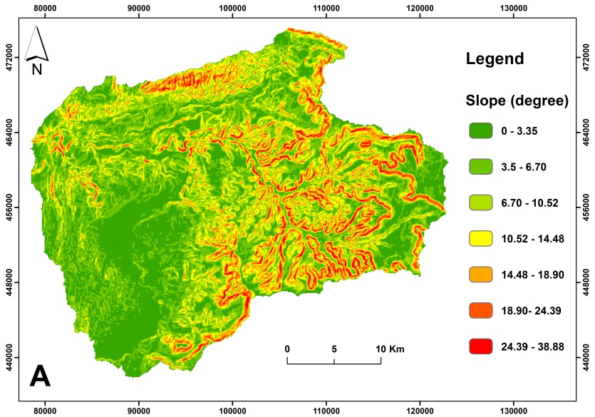
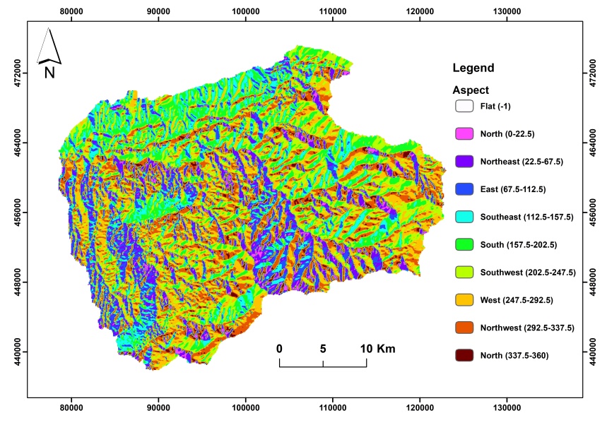
The vegetation and precipitation are more or less affected by the aspect of the topography (Singh et al., 2019), The aspect of the Igouzoulen River is shown in Figure 5c, clearly indicating the north, northwest, south, and southwest-facing slopes of the basin. The northern and northwestern slopes are recognized for their elevated humidity levels and dense vegetation cover, in contrast to the southern and southwestern slopes, which are characterized by high evaporation rates and a scarcity of vegetation cover. The slopes of the basin differ based on the rock characteristics in each segment of the basin, influencing the speed at which water reaches the rivers. The degree of slope in the Igouzoulen Basin spans from 1 to 360 degrees (Figure 5a)
3.3.Relief ratio (Rs)
The maximum relief to horizontal distance along the longest dimension of the basin parallel to the principal drainage line is termed as relief ratio (Schumm, 1956) according to (Kanhaiya et al., 2019). The calculated value of relief ratio for the Igouzoulen basin is 23,01 m/km as in Table 3.
Basin relief (R) is the difference in the elevation between the highest and the lowest point of the basin (Hadley & Schumm, 1961). The low value of relief ratio means low relief and the high value means steep slope and high relief (Sukristiyanti et al., 2018). Basin relief depends upon the underlying geology, geomorphology, and drainage characteristics of the region (Mahala, 2020). In this study, the results showed that the Basin relief reached 1206. the relative relief is the same as 1206. which seems very high for erosional activity (Mahala, 2020). Comparing the basin area with the planar and relative elevation allows us to infer that the river basin is still in its youthful stage, actively eroding substantial sediment quantities due to the fragile rock foundation of the basin (Figure 2).
3.5. Hypsometric curve
The hypsometric analysis is the association of horizontal cross-sectional drainage basin area to elevation. Langbein (1947) introduced the concept to articulate the general slope and configurations of a drainage basin. In simpler terms, this was a method to convey the overall incline and shapes within a drainage basin. More importantly, the graphical shape of the hypsometric curve is an indication of watershed age at landscape evolution. Accordingly, a basin with the upwards convex hypsometric curve is at its youth stage, an S-shaped curve indicates a mature stage and upward concave curves show the basin on peneplain or old age stages of landscape evolution (Strahler, 1952) according to (Asfaw and Workineh, 2019). As indicated in Figure 4 the hypsometric curve of both sub-watersheds is convex upward which connotes that the sub-watershed was in its youth stage of land evolution.
Figure 4: Hypsometric curve of Igouzoulen sub-watershe
|
Maximum Elevation (H) |
Relief ratio (Rs) |
Basin relief (R) |
Degree of Slope(S) |
|
|
0 |
1206 |
23,01 |
1206 |
<3,35 to >38,88 |
Table 3: Relief Morphometric Characteristics of River Catchment
c
Figure 5: showing (A) slop map and (B) elevation map (C) aspect map of Igouzoulen river basin
CONCLUSION
Several factors influence the morphometric characteristics of river basins, including geology, geomorphology, topography, and slope. Additionally, climatic characteristics impact vegetation cover and the dynamics of flow. The parameter also denotes the phases in the geomorphic development of a given region. These morphometric measurements play a crucial role in the planning phase to address hydrological risks and prepare water basins, safeguarding them against erosion and promoting water conservation. The Igouzoulen basin is situated in semi-arid bioclimatic regions characterized by an intricate water network on delicate rocks and slopes, often exhibiting sparse vegetation cover. The basin is predominantly found at altitudes exceeding 1200 meters. This suggests that water flow tends to be abrupt and instantaneous, with a short concentration time due to the basin’s relatively small size. The irregular changes in stream length of the Igouzoulen river basin throughout the different order indicate the younger or rejuvenated stage of river basin development. The consistent increase in the value of Rb is a distinctive feature of semi-arid regions, this value also indicates the basin’s vulnerability to floods. The areal morphometric characteristics of the Igouzoulen basin also indicate a substantial amount of water discharge and peak flow occurring in a relatively short period, these characteristics also suggest the presence of younger stages of geomorphic development in the plateaus of Haha.
References:
- Ali, S.A., Khan, N., 2013. Evaluation of Morphometric Parameters—A Remote Sensing and GIS Based Approach.
- Arthur N . Strahler, 1957. Quantitative analysis of watershed geomorphology. Eos Trans. Am. Geophys. Union 38, 913–920. https://doi.org/10.1029/TR038i006p00913
- Asfaw, D., Workineh, G., 2019. Quantitative analysis of morphometry on Ribb and Gumara watersheds: Implications for soil and water conservation. Int. Soil Water Conserv. Res. 7, 150–157. https://doi.org/10.1016/j.iswcr.2019.02.003
- Charton, R., Kluge, C., Fernández-Blanco, D., Duval-Arnould, A., Bryers, O., Redfern, J., Bertotti, G., 2021. Syn-depositional Mesozoic siliciclastic pathways on the Moroccan Atlantic margin linked to evaporite mobilisation. Mar. Pet. Geol. 128, 105018. https://doi.org/10.1016/j.marpetgeo.2021.105018
- Chorley, R., 1995. Horton, R.E. 1945: Erosional development of streams and their drainage basins: hydrophysical approach to quantitative morphology. Bulletin of the Geological Society of America 56, 2 75-3 70. Prog. Phys. Geogr. Earth Environ. 19, 533–554. https://doi.org/10.1177/030913339501900406
- EL ouahidi ,A (2008). Etude morphosidimentaire des héritages pléistocènes et holocènes de la base vallée de l’oued tamri (maroc). Thèse Doct. D’état, Nancy.
- Hadley, R. and Schumm, S. (1961) Sediment Sources and Drainage Basin Characteristics in Upper Cheyenne River Basin. US Geological Survey Water-Supply Paper 1531-B, Washington DC, 198.
- Kanhaiya, S., Singh, B.P., Singh, S., Mittal, P., Srivastava, V.K., 2019. Morphometric analysis, bedload sediments, and weathering intensity in the K hurar R iver B asin, central I ndia. Geol. J. 54, 466–481. https://doi.org/10.1002/gj.3194
- Kulkarni, M.D., 2013. The Basic Concept to Study Morphometric Analysis of River Drainage Basin: A Review 4.
- Mahala, A., 2020. The significance of morphometric analysis to understand the hydrological and morphological characteristics in two different morpho-climatic settings. Appl. Water Sci. 10, 33. https://doi.org/10.1007/s13201-019-1118-2
- Mazahir, S., Javed, A., Khanday, M.Y., 2022. Drainage Basin Characteristics of Dhund River Basin, Eastern Rajasthan India, Using Remote Sensing and GIS Techniques. J. Geogr. Inf. Syst. 14, 347–363. https://doi.org/10.4236/jgis.2022.144019
- Mesa, L.M., 2006. Morphometric analysis of a subtropical Andean basin (Tucumán, Argentina). Environ. Geol. 50, 1235–1242. https://doi.org/10.1007/s00254-006-0297-y
- Pareta, K., Pareta, U., 2011. Quantitative Morphometric Analysis of a Watershed of Yamuna Basin, India using ASTER (DEM) Data and GIS 2.
- Potter, P.E., 1957. A Quantitative Geomorphic Study of Drainage Basin Characteristics in the Clinch Mountain Area, Virginia and Tennessee . V. C. Miller. J. Geol. 65, 112–113. https://doi.org/10.1086/626413
- Rai, P.K., Mohan, K., Mishra, S., Ahmad, A., Mishra, V.N., 2017. A GIS-based approach in drainage morphometric analysis of Kanhar River Basin, India. Appl. Water Sci. 7, 217–232. https://doi.org/10.1007/s13201-014-0238-y
- Rai, P.K., Singh, P., Mishra, V.N., Singh, A., Sajan, B., Shahi, A.P., 2019. Geospatial Approach for Quantitative Drainage Morphometric Analysis of Varuna River Basin, India. J. Landsc. Ecol. 12, 1–25. https://doi.org/10.2478/jlecol-2019-0007
- Sahu, N., Obi Reddy, G.P., Kumar, N., Nagaraju, M.S.S., Srivastava, R., Singh, S.K., 2017. Morphometric analysis in basaltic Terrain of Central India using GIS techniques: a case study. Appl. Water Sci. 7, 2493–2499. https://doi.org/10.1007/s13201-016-0442-z
- Singh, P., Gupta, A., Singh, M., 2014. Hydrological inferences from watershed analysis for water resource management using remote sensing and GIS techniques. Egypt. J. Remote Sens. Space Sci. 17, 111–121. https://doi.org/10.1016/j.ejrs.2014.09.003
- Singh, S., Kanhaiya, S., Singh, A., Chaubey, K., 2019. Drainage network characteristics of the Ghaghghar River Basin (GRB), Son Valley, India. Geol. Ecol. Landsc. 3, 159–167. https://doi.org/10.1080/24749508.2018.1525670
- Smiej, M.F., Lacaze, B., Aboudi, A.E., Layelmam, M., 2010. Etude du milieu naturel de l’arganeraie de la région de Tamanar. Cartographie et estimation de la densité de l’arganier par télédétection spatiale.
- Strahler, A.N., 1958. DIMENSIONAL ANALYSIS APPLIED TO FLUVIALLY ERODED LANDFORMS. Geol. Soc. Am. Bull. 69, 279. https://doi.org/10.1130/0016-7606(1958)69[279:DAATFE]2.0.CO;2
- Sukristiyanti, S., Maria, R., Lestiana, H., 2018. Watershed-based Morphometric Analysis: A Review. IOP Conf. Ser. Earth Environ. Sci. 118, 012028. https://doi.org/10.1088/1755-1315/118/1/012028
- Vignesh Kumar, M. and Karuppasamy, S. (2012) Land Use and Climate Change Impact on the Streamflow of the Tamirabarani River Basin. International Journal of Advanced Remote Sensing and GIS, 1, 1-11.
- Yunus, A.P., Oguchi, T., Hayakawa, Y.S., 2014. Morphometric Analysis of Drainage Basins in the Western Arabian Peninsula Using Multivariate Statistics. Int. J. Geosci. 05, 527–539. https://doi.org/10.4236/ijg.2014.55049