
Groundwater Vulnerability to Agricultural Pollution Using the Modified DRASTIC Index: A Case Study of Ben Yakhlef, Morocco
قابلية المياه الجوفية للتلوث الزراعي باستخدام مؤشر DRASTIC المعدّل: دراسة حالة بني يخلف، المغرب
Dr. Mounir Neddi¹, Dr. Mohammed kaoini², Prof. Rachida El Morabet3
"1. PhD Student, Hassan II University, Faculty of Arts and Humanities, Mohammedia.
2. PhD Student, Hassan II University, Faculty of Arts and Humanities, Mohammedia.
3. Professor, Hassan II University, Faculty of Arts and Humanities, Mohammedia.
Corresponding Email: neddimounir97@gmail.com"
DOI: https://doi.org/10.53796/hnsj611/7
Arabic Scientific Research Identifier: https://arsri.org/10000/611/7
Volume (6) Issue (11). Pages: 108 - 115
Received at: 2025-10-07 | Accepted at: 2025-10-15 | Published at: 2025-11-01
Abstract: This study assesses the vulnerability of groundwater to agricultural pollution in the Ben Yakhlef commune, Mohammedia Prefecture (Morocco), using a modified DRASTIC index integrated with the SI method and Geographic Information Systems (GIS). The modification replaced two classical parameters—recharge and hydraulic conductivity—with precipitation and land use to better reflect local hydrogeological and anthropogenic conditions. Seven parameters (depth to water, precipitation, aquifer and soil media, topography, vadose zone impact, and land use) were classified, weighted, and spatially analyzed to compute a vulnerability index. The resulting vulnerability map revealed three distinct zones: high, moderate, and low vulnerability. High-risk areas were concentrated along irrigated farmlands near the inter-municipal landfill and Oued Nfifikh, where shallow aquifers, permeable formations, and intensive agrochemical use amplify contamination risks. Moderate vulnerability zones corresponded to flat, intensively farmed areas with poor drainage, while low vulnerability zones occurred in rainfed or forested areas with impermeable soils and steep slopes. Findings confirm that land use and irrigation intensity are decisive in shaping groundwater vulnerability, outweighing purely natural factors. The modified DRASTIC index effectively identified contamination hotspots, emphasizing the need for integrated groundwater management combining improved fertilizer practices, wastewater control, and land-use regulation. This approach supports sustainable agriculture and safe drinking water protection in rapidly urbanizing and industrializing regions of Morocco.
Keywords: groundwater vulnerability, modified DRASTIC index, agricultural pollution, GIS mapping, Ben Yakhlef, Morocco.
المستخلص: تقيّم هذه الدراسة قابلية المياه الجوفية للتلوث الزراعي في بني يخلف بإقليم المحمدية (المغرب) باستخدام مؤشر DRASTIC المعدّل المدمج مع طريقة SI ونظم المعلومات الجغرافية (GIS). تم تعديل النموذج الأصلي من خلال استبدال عاملين من العوامل السبعة التقليدية، وهما إعادة التغذية (Recharge) والناقلية الهيدروليكية (Hydraulic Conductivity)، بعاملي الهطول المطري (Precipitation) واستخدامات الأراضي (Land Use)، وذلك لتكييف المؤشر مع الخصائص الهيدروجيولوجية والبشرية المحلية. تم تصنيف العوامل السبعة (عمق المياه الجوفية، الهطول المطري، وسط الخزان الجوفي، وسط التربة، الطبوغرافيا، تأثير المنطقة غير المشبعة، واستخدامات الأراضي)، ومنحها أوزانًا نسبية، ثم تحليلها مكانيًا باستخدام نظم المعلومات الجغرافية لإنتاج خريطة توضح مستويات القابلية للتلوث. أظهرت النتائج ثلاث مناطق رئيسية من حيث القابلية: مرتفعة، ومتوسطة، ومنخفضة. تتركز المناطق عالية القابلية في الأراضي الزراعية المروية المجاورة للمطرح البلدي المشترك ووادي النفيفيخ، حيث تساهم المياه الجوفية السطحية، والتكوينات شديدة النفاذية، والممارسات الزراعية المكثفة في زيادة خطر التلوث بالنترات والملوثات الأخرى. أما المناطق ذات القابلية المتوسطة، فتتواجد أساسًا في الحقول الزراعية المسطحة ذات الاستعمال المكثف للأسمدة والمبيدات، والتي تعاني من ضعف الصرف الطبيعي وتراكم الملوثات. في المقابل، تظهر المناطق منخفضة القابلية في الأراضي البعلية والمناطق الغابية الواقعة على منحدرات حادة وترب غير منفذة، حيث يحد انخفاض استخدام المواد الكيميائية الزراعية من خطر التلوث. أكدت النتائج أن استخدامات الأراضي وكثافة الري هي العوامل الحاسمة في تحديد قابلية المياه الجوفية للتلوث، متجاوزة العوامل الطبيعية البحتة. أثبت مؤشر DRASTIC المعدّل فعاليته في تحديد المناطق الحرجة، مما يؤكد ضرورة اعتماد نهج إداري متكامل يشمل تحسين ممارسات التسميد والري، وضبط إدارة النفايات الصلبة والسائلة، وتنظيم استخدام الأراضي لضمان استدامة الزراعة وحماية موارد مياه الشرب.
الكلمات المفتاحية: قابلية المياه الجوفية، مؤشر DRASTIC المعدّل، التلوث الزراعي، نظم المعلومات الجغرافية، بني يخلف، المغرب.
Introduction
Groundwater is a vital resource for Morocco, particularly in regions of intensive agriculture and industry. In Mohammedia Prefecture, aquifer quality is increasingly threatened by uncontrolled landfills, untreated wastewater, and excessive use of fertilizers and pesticides, creating serious risks for the environment, farming, and public health (Mabrouki, et al., 2019).
To address these pressures, this study applies a Modified DRASTIC framework that combines elements of the classical index with the SI method. The approach was tailored to the specific hydrogeological and land-use conditions of the Ben Yakhlef commune, where irrigated and rainfed farming, urban growth, and industrial activities converge. Through GIS-based mapping, the research provides a refined assessment of nitrate-related vulnerability and highlights priority areas for groundwater protection. (Batchi, 2017)
Materials and Methods
The study was conducted in the Ben Yakhlef commune, Mohammedia Prefecture (Morocco), an area characterized by intensive demographic, agricultural, and industrial activities. Its shallow aquifers are highly exposed to contamination, particularly from agricultural inputs, which justified applying a groundwater vulnerability assessment (Mabrouki, et al., 2019). The analysis relied on the DRASTIC index, which evaluates groundwater vulnerability through seven parameters: depth to water, net recharge, aquifer and soil media, topography, vadose zone, and hydraulic (Aller, 1987). To better reflect local conditions dominated by nitrate pollution, two modifications were introduced (Batchi, 2017) (Patel, et al., 2022): recharge was replaced by precipitation, given the central role of rainfall in transporting and leaching agricultural chemicals (Dzhamalov & Zlobina, 1996), while hydraulic conductivity was substituted by land use to account for the impact of intensive irrigated
farming and to highlight zones where multiple contamination sources overlap with agricultural activities (Batchi, 2017). The final parameters (D, P, A, S, T, I, U) were classified, rated on a scale of 1–10, and weighted, with the vulnerability index computed as:
DI=(D×5)+(P×2)+(A×3)+(S×2)+(T×1)+(I×5)+(U×5) (Aller, 1987)
D = Depth to water (Mabrouki, et al., 2019) – P = Precipitation (meteoblue, 2021) – A = Aquifer media (Service géologique du Maroc, 1921) – S = Soil media (FAO–UNESCO, 1977) – T = Topography (Survey, 2020) – I = Impact of vadose zone (Survey, 2019) – L = Land use (Google Earth, 2O21).
All parameter layers were derived from hydrogeological surveys, rainfall records, soil and land-use maps, DEMs, and field observations and were processed in ArcGIS to generate the groundwater vulnerability map (Patel, et al., 2022).
Fig.1. Comparison Between Original and Modified DRASTIC Methodology
|
Original DRASTIC Parameters |
Modified DRASTIC Parameters |
|
Water Table Depth (D) |
Depth to water (D) |
|
Net Recharge (R) |
Precipitation (P) |
|
Aquifer Media (A) |
Aquifer media (A) |
|
Soil Media (S) |
Soil Media (S) |
|
Topography / Slope (T) |
Topography (T) |
|
Impact of the Vadose Zone (I) |
Impact of the Vadose Zone (I) |
|
Hydraulic Conductivity (C) |
Land Use (L) |
|
Fig.2. Modified DRASTIC Parameters and Ratings (Translated) |
||
|
Class |
Rating |
|
|
D – Depth to water (Weight = 5) |
||
|
0 – 1.5 |
10 |
|
|
1.5 – 4.5 |
9 |
|
|
4.5 – 9 |
7 |
|
|
9 – 15 |
5 |
|
|
15 – 22 |
3 |
|
|
22 – 30 |
2 |
|
|
> 30 |
1 |
|
|
P – Precipitation (Weight = 2) |
||
|
< 250 |
1 |
|
|
256 – 650 |
4 |
|
|
650 – 1000 |
6 |
|
|
1000 – 2000 |
7 |
|
|
2000 – 3000 |
9 |
|
|
> 3000 |
10 |
|
|
A – Aquifer Media (Weight = 3) |
||
|
Karstic limestone |
10 |
|
|
Basalt |
9 |
|
|
Sand and gravel |
8 |
|
|
Massive limestone |
6 |
|
|
Massive sandstone |
6 |
|
|
Shale |
6 |
|
|
sandstone and limestone |
4 |
|
|
Metamorphic rocks |
3 |
|
|
Massive shale |
2 |
|
|
S – Soil Media (Weight = 2) |
||
|
Thin or absent soil |
10 |
|
|
Gravel |
10 |
|
|
Sand |
9 |
|
|
Colluvial clay deposits |
7 |
|
|
Sandy silt |
6 |
|
|
Silt |
5 |
|
|
Fine silt |
4 |
|
|
Silty clay |
3 |
|
|
Massive unfractured clay |
1 |
|
|
T – Topography / Slope (Weight = 1) |
||
|
0 – 2 % |
10 |
|
|
2 – 6 % |
9 |
|
|
6 – 12 % |
5 |
|
|
12 – 18 % |
3 |
|
|
> 18 % |
1 |
|
|
I – Impact of the Vadose Zone (Weight = 5) |
||
|
Karstic limestone |
10 |
|
|
Basalt |
9 |
|
|
Sand and gravel |
8 |
|
|
Sands, gravels, clays, and silts |
6 |
|
|
Dolomitic limestone, Sandstone, Shale |
6 |
|
|
Sandstone |
6 |
|
|
L – Land Use (Weight = 5) |
||
|
Irrigated agriculture |
10 |
|
|
Industry and quarries |
9 |
|
|
Urban settlements |
8 |
|
|
Rainfed agriculture |
7 |
|
|
Forests and natural vegetation |
6 |
|
|
Pastures |
5 |
|
|
DRASTIC Index Formula |
||
|
DI = (D × 5) + (P × 2) + (A × 3) + (S × 2) + (T × 1) + (I × 5) + (U × 5) |
||
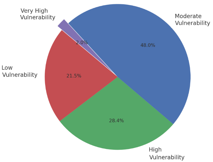
Fig.3. Distribution of Irrigated Agricultural Lands in Ben Yakhlef According to Groundwater Vulnerability
Results
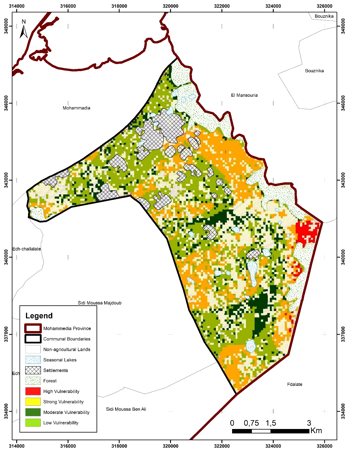
The spatial analysis of groundwater vulnerability in Ben Yakhlef reve als marked contrasts shaped by the interaction of agricultural practices, waste management, and hydrogeological conditions. Critical zones, although spatially limited, constitute the most alarming hotspots. They are located in irrigated farmlands adjacent to the inter-municipal landfill, where shallow aquifers, highly permeable formations, and favorable topographic gradients create optimal conditions for infiltration. In these areas, the cumulative effect of intensive agrochemical inputs and leachate from solid waste disposal significantly increases the risk of groundwater contamination (Lamouadene & El Morabet, 2025).
High vulnerability areas are concentrated along the agricultural lands of the left bank of Oued Nfifikh. Here, irrigated farming coincides with the discharge of untreated liquid effluents into the river, and the presence of shallow water tables further amplifies the susceptibility of aquifers to nitrate leaching and other pollutants (Merbouh, et al., 2022).
Moderate vulnerability zones correspond mainly to intensively irrigated agricultural fields characterized by higher consumption of fertilizers and pesticides. They are generally located on flat terrains and depressions, where elevated piezometric levels and weak natural drainage slow contaminant dilution and favor their accumulation. The proximity of these farmlands to residential clusters, industrial facilities, and quarrying operations further compounds the risks, leading to multi-source pressures on groundwater quality. (Acharya, et al., 2025)
Low vulnerability areas are associated with rainfed agriculture established on sloping terrains underlain by semi-permeable to impermeable soils. In these zones, elevated piezometric levels, higher drainage capacity, and reduced use of agrochemicals collectively mitigate contamination risks, providing relative protection to groundwater resources. (Acharya, et al., 2025)
Overall, the results underscore that groundwater vulnerability in Ben Yakhlef is not uniformly distributed but is strongly determined by land use and irrigation intensity. Hydrogeological settings—such as depth to water, permeability, and slope—either exacerbate or buffer these anthropogenic pressures, while the combined influence of agricultural practices and waste management remains the decisive driver of contamination risk (Mabrouki, et al., 2019).
Discussion
Groundwater vulnerability in Bni Yakhlef is shaped by the interaction between hydrogeological and topographic conditions and strong human pressures. While shallow aquifers and permeable formations create a naturally fragile setting, contamination risks become critical where they overlap with landfill leachate, intensive irrigation, and urban–industrial activities. (Mabrouki, et al., 2019)
The modified DRASTIC index, which replaces hydraulic conductivity with land use, proved effective in highlighting the decisive role of human activities (Batchi, 2017). Irrigated farmlands and landfill zones emerged as the most vulnerable hotspots, confirming local evidence of high nitrate levels (Mabrouki, et al., 2019) and supporting international findings that land use often outweighs hydrogeology in groundwater quality control (Batchi, 2017).
A clear contrast was observed between systems: irrigated agriculture sustains productivity but drives nitrate leaching, while rainfed fields and forested areas show low vulnerability thanks to limited agrochemical inputs and protective natural recharge (Naamane, et al., 2021) (Dzhamalov & Zlobina, 1996). Vulnerability was highest where multiple sources converge, particularly in the landfill–Oued Nfifikh corridor, where agricultural, industrial, and domestic effluents combine (Mabrouki, et al., 2019), echoing patterns reported in other peri-urban areas recharge (Yu, et al., 2024).
From a management perspective, groundwater protection requires an integrated approach combining stricter monitoring of hotspots, improved fertilizer and irrigation practices, and urgent reforms in solid and liquid waste management. Without these measures, the persistence of nitrate leaching and leachate infiltration will continue to endanger both drinking-water safety and the sustainability of local farming systems.
Fig.4. Groundwater Pollution Vulnerability of Agricultural Lands in Beni Yakhlef Commune
Conclusion
Groundwater in Bni Yakhlef is highly vulnerable, mainly due to irrigated agriculture and waste disposal, with hydrogeological and topographic conditions acting as amplifiers. The modified DRASTIC index, integrating land use, effectively identified the landfill–Oued Nfifikh corridor as the most critical hotspot, confirming that human pressures outweigh natural settings in shaping groundwater quality.
Findings align with regional studies showing that fertilizer and pesticide use, poor waste management, and the overlap of agricultural, industrial, and residential activities create cumulative risks, while rainfed and forested areas remain less vulnerable. Protecting groundwater therefore requires integrated strategies combining sustainable farming practices, stricter input regulation, and improved waste management to ensure safe drinking water and long-term agricultural sustainability.
References
- Acharya, L. P. P. T. K. e. a., 2025. Pesticide contamination in groundwater: processes, risks, and mitigation strategies. Discover Agriculture, p. 152.
- Aller, L. B. T. L. J. P. R. a. H. G., 1987. DRASTIC: A standardized system for evaluating ground water pollution potential using hydrogeologic settings, U.S: EPA Report 600/2-87/035. U.S. Environmental Protection Agency..
- Batchi, M. A. K. J. F. I. &. E. M. M., 2017. Étude comparative de deux modèles (DRASTIC et SI) pour l’évaluation de la sensibilité de la nappe phréatique de Mnasra (Maroc nord-occidental) à la pollution d’origine agricole. Physio-Géo, 11. https://doi.org/10.4000/physio-geo.5213, p. 43–64.
- Dzhamalov, R. a. Z. V., 1996. The role of precipitation in groundwater pollution. Springer doi:10.1007/978-94-009-0205-3_22, p. 493–507.
- FAO–UNESCO, 1977. Soil Map of the World, 1:5,000,000. Africa. Paris: UNESCO. Disponible sur: https://www.fao.org/3/as357e/as357e.pdf.
- Google Earth, 2025. Satellite image of Bni Yakhlef, Morocco [Imagery]. Google Earth.
- Lamouadene, Y. &. E. M. R., 2025. Landfill’s leachate impacts on the groundwater quality: A case study in Mohammedia prefecture, Morocco. Environmental Science and Pollution Research.
- Mabrouki, J., El Yadini, A., Bencheikh, I. & Azoula, 2019. Hydrogeological and hydrochemical study of underground waters of the tablecloth in the vicinity of the controlled city dump Mohammedia (Morocco). Springer. https://doi.org/10.1007/978-3-030-11881-5_3, p. (AI2SD 2018) (pp. 22–33).
- Merbouh, C. K. M. N. A. R. A. &. I. N., 2022. Physicochemical Characterization and Metallic Contamination of the Waters of Oued Nfifikh (Morocco). Ecological Engineering & Environmental Technology, p. 1–11.
- meteoblue, 2021. Precipitation data for Ben Yakhlef, Morocco [Dataset]. meteoblue, Retrieved from https://www.meteoblue.com.
- Ministère de l’Environnement du Québec, 2002. Méthode DRASTIC: Fiche technique pour l’évaluation de la vulnérabilité des eaux souterraines à la pollution. Gouvernement du Québec. Retrieved from https://www.environnement.gouv.qc.ca/eau/souterraines/drastic/fiche-drastic.pdf, p. (11 p.).
- Naamane, S. K. M. &. A. E. M. A., 2021. Enquête sur l’utilisation des engrais et pesticides chez les agriculteurs de la région de Casablanca-Settat. Researchgate.
- Patel, P. M. D. &. S. N., 2022. A review on the application of the DRASTIC method in the assessment of groundwater vulnerability. Water Science & Technology: Water Supply, p. 5190–5209.
- Sanad, H., 2024. Groundwater pollution by nitrate and salinization in Morocco: a comprehensive review. Journal of Water and Health, pp. 1756-1773.
- Service géologique du Maroc, 1921. Carte géologique provisoire des environs de Casablanca. [map] Paris: Service géologique du Maroc.
- Survey, B. G., 2019. Africa Groundwater Atlas. British Geological Survey.
- Survey, U. G., 2020. Digital Elevation Model for Bni Yakhlef, Morocco [Dataset]. USGS EarthExplorer: https://earthexplorer.usgs.gov.
- Yu, D. D. J. J. Q. L. H. Y. C. M. H. &. P. S., 2024. Evaluation of groundwater quality with multi-source pollution based on source identification and health risks.. Science of The Total Environment, p. Article 175064.